 |
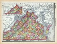
Page 070 - Virginia |
World Atlas 1911c from Minneso... |
 |
Rand, McNally and Co... |
1911 |
HMW |
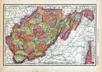 |
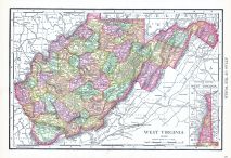
Page 071 - West Virginia |
World Atlas 1911c from Minneso... |
|
Rand, McNally and Co... |
1911 |
HMW |
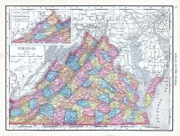 |
Virginia |
World Atlas 1913 |
|
Rand McNally and Com... |
1913 |
HMW |
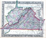 |
Virginia and West Virginia |
World Atlas 1864 Mitchells New... |
|
S. Augustus Mitchell |
1864 |
HMW |
 |
West Virginia |
World Atlas 1913 |
|
Rand McNally and Com... |
1913 |
HMW |
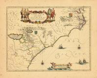 |
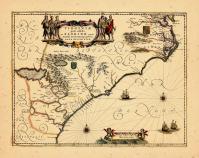
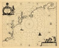
Map - Page 1 |
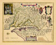
Virginiae Partis Australis et ... |
|
Blaeu, William |
1655 |
OML |
|
 |
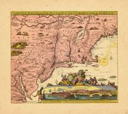
Map - Page 1 |
D'Engelze Volkplanting in Virg... |
|
AA, Pieter van der |
1707 |
OML |
|
 |
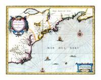
Map - Page 1 |
Virginiae Partis Australis et ... |
|
Jansson, Jan |
1644 |
OML |
|
 |
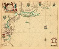
Map - Page 1 |
Virginiae partis australis et ... |
|
Jansson |
1658 |
OML |
|
 |
Map - Page 1 |
NOVA ANGLIA/NOVVM BELGIVM/et/V... |
|
JANSSON, JAN |
1639-49 |
OML |
|
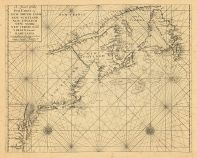 |
Map - Page 1 - A Chart of the/... |
A Chart of the/Sea Coast of/NE... |
|
THORNTON, JOHN / MOU... |
1713 |
OML |
|
 |
Map - Page 1 - A Chart/of the ... |
A Chart/of the Sea coasts of/N... |
|
SELLER, JOHN |
1675- |
OML |
|
 |
Map - Page 1 - A Draught of/VI... |
A Draught of/VIRGINIA/from the... |
|
TIDDEMAN, MARK (MOUN... |
1755 |
OML |
|
 |
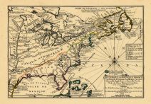
Map - Page 1 - A General/MAP o... |
A General/MAP of the/MIDDLE BR... |
|
EVANS, LEWIS / BOWLE... |
1765- |
OML |
|
 |
Map - Page 1 - A MAP of the/BR... |
A MAP of the/BRITISH/AMERICAN ... |
|
BOWEN, EMANUEL |
1754 |
OML |
|
 |
Map - Page 1 - A MAP OF THE/UN... |
A MAP OF THE/UNITED STATES/of/... |
|
ARROWSMITH, AARON |
1799 |
OML |
|
 |
Map - Page 1 - A New Chart for... |
A New Chart for the/Seacoasts ... |
|
THORNTON, JOHN/FISHE... |
1687 |
OML |
|
 |
Map - Page 1 - A New Chart of ... |
A New Chart of the Sea Coast o... |
|
THORNTON, JOHN |
1685- |
OML |
|
 |
Map - Page 1 - A NEW MAP OF NE... |
A NEW MAP OF NEW ENGLAND-NEW Y... |
|
THORNTON, JOHN /ROBE... |
1690- |
OML |
|
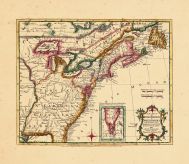 |
Map - Page 1 - A New MAP of/th... |
A New MAP of/the/BRITISH DOMIN... |
|
ANNUAL REGISTER / KI... |
1763 |
OML |
|
 |
Map - Page 1 - A NEW MAPP OF/N... |
A NEW MAPP OF/NEW ENGLAND/and/... |
|
BROWNE, C[HRISTOPHER... |
1714 |
OML |
|
 |
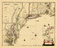
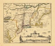
Map - Page 1 - BELGII NOVI,/AN... |
BELGII NOVI,/ANGLIAE NOVAE, ET... |
|
JANSSON, JAN / SCHEN... |
1694 |
OML |
|
 |
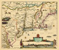
Map - Page 1 - BELGII NOVI,/AN... |
BELGII NOVI,/ANGLIAE NOVAE, ET... |
|
JANSSONIUS, JOANNES |
1651 |
OML |
|
 |
Map - Page 1 - CANADA/ou/NOVVE... |
CANADA/ou/NOVVELLE/FRANCE |
|
MALLET, ALAIN MANESS... |
1686 |
OML |
|
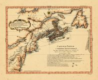 |
Map - Page 1 - CARTE D'UNE PAR... |
CARTE D'UNE PARTIE DE/L'AMERIQ... |
|
BELLIN, JACQUES NICO... |
1756 |
OML |
|
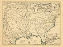 |
Map - Page 1 - CARTE DE LA LOU... |
CARTE DE LA LOUISIANE ET DU CO... |
|
DELISLE, GUILLAUME |
1718 |
OML |
|
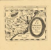 |
Map - Page 1 - CARTE de LA VIR... |
CARTE de LA VIRGINIE |
|
DU VAL, PIERRE |
1670 |
OML |
|
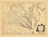 |
Map - Page 1 - CARTE/ DE LA VI... |
CARTE/ DE LA VIRGINIE ET/ DU M... |
|
VAUGONDY, ROBERT de ... |
1755 |
OML |
|
 |
Map - Page 1 - Costes et Riuie... |
Costes et Riuieres/de VIRGINIE... |
|
MICHAULT, R. / JUSTE... |
1674 |
OML |
|
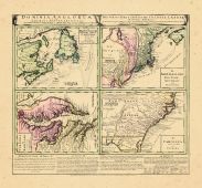 |
Map - Page 1 - DOMINIA ANGLORU... |
DOMINIA ANGLORUM/in/AMERICA SE... |
|
HOMANN HEIRS/MOLL, H... |
1737- |
OML |
|
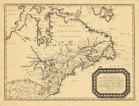 |
Map - Page 1 - LE CANADA,ou No... |
LE CANADA,ou Nouvelle France,a... |
|
SANSON, NICOLAS |
1656 |
OML |
|
 |
Map - Page 1 - LE CANADA,ou NO... |
LE CANADA,ou NOUVELLE FRANCE/R... |
|
FER, NICOLAS de |
1702 |
OML |
|
 |
Map - Page 1 - LE CANADA/faict... |
LE CANADA/faict par le Sr. de ... |
|
CHAMPLAIN, SAMUEL de... |
1653 |
OML |
|
 |
Map - Page 1 - Le Cours du/MIS... |
Le Cours du/MISSISIPI,/ou de S... |
|
FER, NICOLAS DE |
1718 |
OML |
|
 |
Map - Page 1 - MAPPA/GEOGRAPHI... |
MAPPA/GEOGRAPHICA/AMERICAE/SEP... |
|
EULER, LEONHARD von |
1755 |
OML |
|
 |
Map - Page 1 - New and Exact M... |
New and Exact MAP of the DOMIN... |
|
MOLL, HERMAN |
1732+ |
OML |
|
 |
Map - Page 1 - NOUVELLE ANGLET... |
NOUVELLE ANGLETERRE/NLLE. YORK... |
|
VAUGONDY, ROBERT de,... |
1749 |
OML |
|
 |
Map - Page 1 - NOUVELLE/HOLLAN... |
NOUVELLE/HOLLANDE,/(a present/... |
|
AA, PIETER VANDER |
1714- |
OML |
|
 |
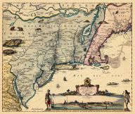
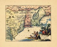
Map - Page 1 - NOVA BELGICA ET... |
NOVA BELGICA ET ANGLIA NOVA |
|
JANSSON, JAN |
1652-58 |
OML |
|
 |
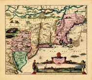
Map - Page 1 - NOVA BELGICA ET... |
NOVA BELGICA ET ANGLIA NOVA |
|
JANSSON, JAN / VALK,... |
1710- |
OML |
|
 |
Map - Page 1 - NOVA TABULA GEO... |
NOVA TABULA GEOGRAPHICA COMPLE... |
|
VISSCHER, NICOLAS / ... |
1700- |
OML |
|
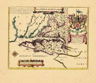 |
Map - Page 1 - Nova TERRAE-MAR... |
Nova TERRAE-MARIAE tabula |
|
OGILBY, JOHN |
1671 |
OML |
|
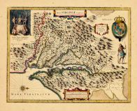 |
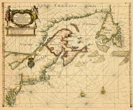
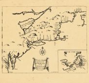
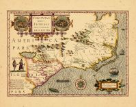
Map - Page 1 - NOVA VIRGINIAE ... |
NOVA VIRGINIAE TABULA |
|
HONDIUS, HENRICUS |
1633 |
OML |
|
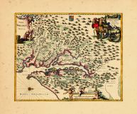 |
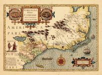
Map - Page 1 - NOVA VIRGINIAE ... |
NOVA VIRGINIAE TABULA |
|
OGILBY, JOHN |
1670 |
OML |
|
 |
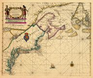
Map - Page 1 - NOVA VIRGINIAE ... |
NOVA VIRGINIAE TABVLA |
|
BLAEU, WILLEM |
1640 |
OML |
|
 |
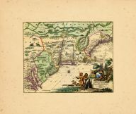
Map - Page 1 - NOVI BELGII NOV... |
NOVI BELGII NOVAEQUE ANGLIAE/P... |
|
VISSCHER, NICOLAS / ... |
1729- |
OML |
|
 |
Map - Page 1 - NOVI BELGII NOV... |
NOVI BELGII NOVAEQUE ANGLIAE/V... |
|
VISSCHER, NICOLAS |
1684 |
OML |
|
 |
Map - Page 1 - NOVI BELGII NOV... |
NOVI BELGII NOVAEQUE ANGLIAE/V... |
|
VISSCHER, NICOLAS |
1656- |
OML |
|
 |
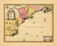
Map - Page 1 - NOVI BELGII,Quo... |
NOVI BELGII,Quod nunc NOVI JOR... |
|
OGILBY, JOHN |
1670 |
OML |
|
 |
Map - Page 1 - NOVI BELGII,Quo... |
NOVI BELGII,Quod nunc NOVI JOR... |
|
OGILBY, JOHN |
1670 |
OML |
|
 |
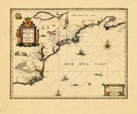
Map - Page 1 - NOVI BELGII/NOV... |
NOVI BELGII/NOVAEQUE ANGLIAE N... |
|
DANCKERS, JUSTO |
1680- |
OML |
|
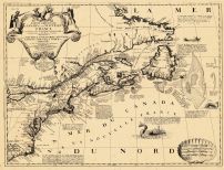 |
Map - Page 1 - PARTIE ORIENTAL... |
PARTIE ORIENTALE DU CANADA |
|
CORONELLI, V.M. / NO... |
1689 |
OML |
|
 |
Map - Page 1 - Pascaerte van/N... |
Pascaerte van/NIEV NEDERLANT,/... |
|
JACOBSZ, THEUNIS [LO... |
1681 |
OML |
|
 |
Map - Page 1 - TIERRA NVEVA |
TIERRA NVEVA |
|
RUSCELLI, GIROLAMO /... |
1598-99 |
OML |
|
 |
Map - Page 1 - TOTIUS NEOBELGI... |
TOTIUS NEOBELGII NOVA ET ACCUR... |
|
ALLARD, HUGO / OTTEN... |
1720- |
OML |
|
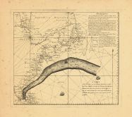 |
Map - Page 1 - UNTITLED CHART ... |
UNTITLED CHART OF THE GULF STR... |
|
LE ROUGE, GEORGES-LO... |
1782- |
OML |
|
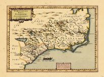 |
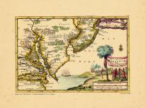
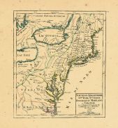
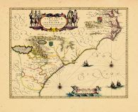
Map - Page 1 - VIRGINIA ITEM e... |
VIRGINIA ITEM et FLORIDAE |
|
DU SAUZET, HENRI |
1734 |
OML |
|
 |
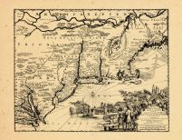
Map - Page 1 - VIRGINIAE ITEM ... |
VIRGINIAE ITEM ET FLORIDAE AME... |
|
HONDIUS, JODOCUS |
1630 |
OML |
|
 |
Map - Page 1 - VIRGINIAE ITEM ... |
VIRGINIAE ITEM ET FLORIDAE AME... |
|
HONDIUS, JODOCUS |
1619 |
OML |
|
 |
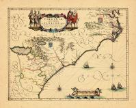
Map - Page 1 - VIRGINIAE/parti... |
VIRGINIAE/partis australis,/et... |
|
BLAEU, WILLEM |
1640 |
OML |
|
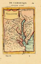 |
Map - Page 1 - VIRGINIE |
VIRGINIE |
|
MALLET, ALAIN MANESS... |
1683 |
OML |
|
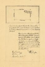 |
Map - Page 1 - [MS INSCRIPTION... |
[MS INSCRIPTION ON VERSO- Patr... |
|
WASHINGTON, GEORGE |
1750 |
OML |
|
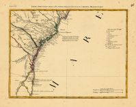 |
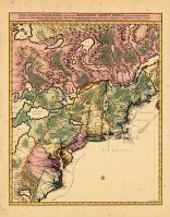
Map - Page 12 - LE COLONIE UNI... |
LE COLONIE UNITE DELL AMERICA ... |
|
MITCHELL, JOHN / ZAT... |
1778 |
OML |
|
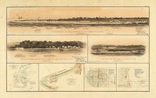 |
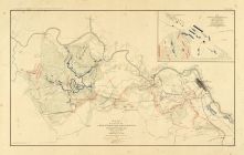
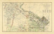
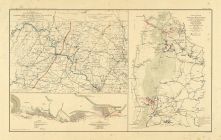
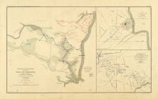
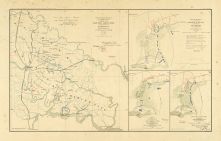
Map - Page 2 - ATLAS/TO ACCOMP... |
ATLAS/TO ACCOMPANY THE OFFICIA... |
|
DAVIS, MAJOR GEORGE ... |
1891 |
OML |
|
 |
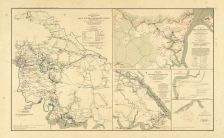
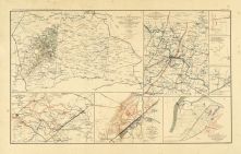
Map - Page 2 - ATLAS/TO ACCOMP... |
ATLAS/TO ACCOMPANY THE OFFICIA... |
|
DAVIS, MAJOR GEORGE ... |
1891 |
OML |
|
 |
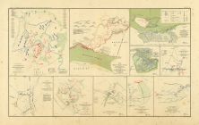
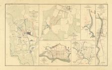
Map - Page 2 - ATLAS/TO ACCOMP... |
ATLAS/TO ACCOMPANY THE OFFICIA... |
|
DAVIS, MAJOR GEORGE ... |
1891 |
OML |
|
 |
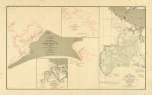
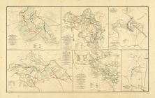
Map - Page 2 - ATLAS/TO ACCOMP... |
ATLAS/TO ACCOMPANY THE OFFICIA... |
|
DAVIS, MAJOR GEORGE ... |
1891 |
OML |
|
 |
Map - Page 2 - ATLAS/TO ACCOMP... |
ATLAS/TO ACCOMPANY THE OFFICIA... |
|
DAVIS, MAJOR GEORGE ... |
1891 |
OML |
|
 |
Map - Page 2 - ATLAS/TO ACCOMP... |
ATLAS/TO ACCOMPANY THE OFFICIA... |
|
DAVIS, MAJOR GEORGE ... |
1891 |
OML |
|
 |
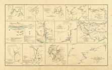
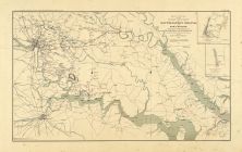
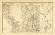
Map - Page 3 - ATLAS/TO ACCOMP... |
ATLAS/TO ACCOMPANY THE OFFICIA... |
|
DAVIS, MAJOR GEORGE ... |
1891 |
OML |
|
 |
Map - Page 3 - ATLAS/TO ACCOMP... |
ATLAS/TO ACCOMPANY THE OFFICIA... |
|
DAVIS, MAJOR GEORGE ... |
1891 |
OML |
|
 |
Map - Page 3 - ATLAS/TO ACCOMP... |
ATLAS/TO ACCOMPANY THE OFFICIA... |
|
DAVIS, MAJOR GEORGE ... |
1891 |
OML |
|
 |
Map - Page 3 - ATLAS/TO ACCOMP... |
ATLAS/TO ACCOMPANY THE OFFICIA... |
|
DAVIS, MAJOR GEORGE ... |
1891 |
OML |
|
 |
Map - Page 3 - ATLAS/TO ACCOMP... |
ATLAS/TO ACCOMPANY THE OFFICIA... |
|
DAVIS, MAJOR GEORGE ... |
1891 |
OML |
|
 |
Map - Page 3 - ATLAS/TO ACCOMP... |
ATLAS/TO ACCOMPANY THE OFFICIA... |
|
DAVIS, MAJOR GEORGE ... |
1891 |
OML |
|
 |
Map - Page 3 - ATLAS/TO ACCOMP... |
ATLAS/TO ACCOMPANY THE OFFICIA... |
|
DAVIS, MAJOR GEORGE ... |
1891 |
OML |
|
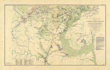 |
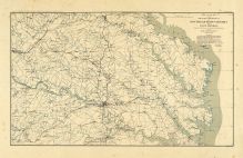
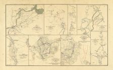
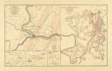
Map - Page 4 - ATLAS/TO ACCOMP... |
ATLAS/TO ACCOMPANY THE OFFICIA... |
|
DAVIS, MAJOR GEORGE ... |
1891 |
OML |
|
 |
Map - Page 4 - ATLAS/TO ACCOMP... |
ATLAS/TO ACCOMPANY THE OFFICIA... |
|
DAVIS, MAJOR GEORGE ... |
1891 |
OML |
|
 |
Map - Page 4 - ATLAS/TO ACCOMP... |
ATLAS/TO ACCOMPANY THE OFFICIA... |
|
DAVIS, MAJOR GEORGE ... |
1891 |
OML |
|
 |
Map - Page 4 - ATLAS/TO ACCOMP... |
ATLAS/TO ACCOMPANY THE OFFICIA... |
|
DAVIS, MAJOR GEORGE ... |
1891 |
OML |
|
 |
Map - Page 4 - UNITED STATES o... |
UNITED STATES of Nth. AMERICA/... |
|
TARDIEU, P.F. [AFTER... |
1812 |
OML |
|
 |
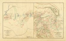
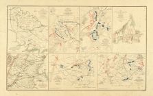
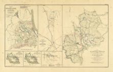
Map - Page 5 - ATLAS/TO ACCOMP... |
ATLAS/TO ACCOMPANY THE OFFICIA... |
|
DAVIS, MAJOR GEORGE ... |
1891 |
OML |
|
 |
Map - Page 5 - ATLAS/TO ACCOMP... |
ATLAS/TO ACCOMPANY THE OFFICIA... |
|
DAVIS, MAJOR GEORGE ... |
1891 |
OML |
|
 |
Map - Page 5 - ATLAS/TO ACCOMP... |
ATLAS/TO ACCOMPANY THE OFFICIA... |
|
DAVIS, MAJOR GEORGE ... |
1891 |
OML |
|
 |
Map - Page 6 - ATLAS/TO ACCOMP... |
ATLAS/TO ACCOMPANY THE OFFICIA... |
|
DAVIS, MAJOR GEORGE ... |
1891 |
OML |
|
 |
Map - Page 6 - ATLAS/TO ACCOMP... |
ATLAS/TO ACCOMPANY THE OFFICIA... |
|
DAVIS, MAJOR GEORGE ... |
1891 |
OML |
|
 |
Map - Page 6 - ATLAS/TO ACCOMP... |
ATLAS/TO ACCOMPANY THE OFFICIA... |
|
DAVIS, MAJOR GEORGE ... |
1891 |
OML |
|
 |
Map - Page 6 - ATLAS/TO ACCOMP... |
ATLAS/TO ACCOMPANY THE OFFICIA... |
|
DAVIS, MAJOR GEORGE ... |
1891 |
OML |
|
 |
Map - Page 6 - ATLAS/TO ACCOMP... |
ATLAS/TO ACCOMPANY THE OFFICIA... |
|
DAVIS, MAJOR GEORGE ... |
1891 |
OML |
|
 |
Map - Page 6 - ATLAS/TO ACCOMP... |
ATLAS/TO ACCOMPANY THE OFFICIA... |
|
DAVIS, MAJOR GEORGE ... |
1891 |
OML |
|
 |
Map - Page 8 - LE COLONIE UNIT... |
LE COLONIE UNITE DELL AMERICA ... |
|
MITCHELL, JOHN / ZAT... |
1778 |
OML |
|
 |
Map - Page 9 - LE COLONIE UNIT... |
LE COLONIE UNITE DELL AMERICA ... |
|
MITCHELL, JOHN / ZAT... |
1778 |
OML |
|

 Cart
Cart