
 Cart
CartLocation Search results for "Unionville" in Ohio
Map Matches for "Unionville" (11) in Ohio
Click on a column header to sort results table.


Atlas Matches for "Unionville" (0) in Ohio
You may find "Unionville" in these Ohio atlases:
Click on a column header to sort results table.
| Atlas | Publisher | Date | ||
|---|---|---|---|---|
 |
Holmes County 1907 |  |
Standard Atlas Publishing Co. | 1907 |
 |
Holmes County 1875 |    |
Cring, Henry | 1875 |
 |
Holmes County 1861 |  |
H.F. Walling | 1861 |
 |
Columbiana County 1870 | |
C. O. Titus | 1870 |
 |
Columbiana County 1902 | |
Columbiana County Map and Atlas Company | 1902 |
 |
Columbiana County 1860 | |
Carhart, Mead & Co. | 1860 |
 |
Morgan County 1902 | |
Paul R. Murray | 1902 |
 |
Morgan County 1875 | |
Titus, Simmons & Titus | 1875 |
 |
Morgan County 1854 | |
Wallace & Co. Lithographers | 1854 |
 |
Lake County 1898 | |
H. B. Stranah & Co. | 1898 |
 |
Lake County 1930c | |
W. W. Hixon Publishing Co. | 1930 |
 |
Lake County 192x | |
W. W. Hixson and Co. | 192x |
 |
Lake County 1919 | |
Clinton Cowen | 1919 |
 |
Lake County 1915 | |
Century Map Co. | 1915 |
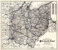 |
Ohio 1883 State and Railroad Map |   |
Ohio 1883 State and Railroad Map | 1883 |
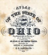 |
Ohio State Atlas 1868 | |
Henry S. Stebbius | 1868 |
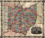 |
Ohio State Map 1854 Township and Railroad Map | |
George W. Colton | 1854 |
 |
Ohio State Highway Maps 1910 | |
State Highway Department of Ohio | 1910 |
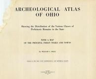 |
Ohio State 1915 Archeological Atlas | |
Fred J. Heer | 1912 |