|
Seattle 1878 Bird's Eye View 16.5x27 |
Seattle 1878 Bird's Eye View |
E. S. Glover |
1878 |
 |
Page 04, Summit, Meadowdale, Martha Lake, Manordale, Alderwood Manor, Cedar Valley, Seattle Heights |
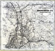
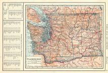
Snohomish County 1934 |
Kroll Map Company |
1934 |
 |
Page 005 - Seattle Heights, Cedar Valley, Lake Ballinger |
Snohomish County 198x |
Chas F. Metsker |
198x |
 |
Page 048, Yakima Indian Reservation, Toppenish Ridge, Seattle Creek, Lousey Creek, Olney Lake |
Yakima County 1934 |
Chas F. Metsker |
1934 |
 |
Seattle 1884 Bird's Eye View 17x30 |
Seattle 1884 Bird's Eye View |
Wellge, H. |
1884 |
 |
Seattle 1891 Bird's Eye View 17x25 |
Seattle 1891 Bird's Eye View |
Koch, Augustus |
1891 |
 |
Seattle 1890 City and Environs Map 17x19 |
Seattle 1890 City and Environs Map |
O. P. Anderson & Co. |
1890 |
 |
Seattle 1890 City and Environs Map 24x27 |
Seattle 1890 City and Environs Map |
O. P. Anderson & Co. |
1890 |
 |
Seattle 1904 Bird's Eye View of Business District 17x19 |
Seattle 1904 Bird's Eye View of Business District |
Periscopic Map Co. |
1904 |
 |
Page 005 - Cedar Valley, Seattle Heights, Lake Ballinger |
Snohomish County 1960 Published by Metskers |
Thos. C. Metsker |
1960 |
 |
Seattle 1925 Bird's Eye View 24x41 |
Seattle 1925 Bird's Eye View |
Edwin C. Poland |
1925 |
 |
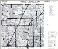
Page 4 Township 27 N, Range 4 E, Meadowdale, Puget Sound, Seattle Heights, Lynnwood |
Snohomish County 1943 Revised 1952 |
Kroll Map Company |
1943 |
 |
Township 27 N. Range 4 E.W.M., Meadowdale, Alderwood Manor, Seattle Heights, Manordale |
Snohomish County 1927 |
Chas. F. Metsker |
1927 |
 |
Township 27 N. Range 4 E.W.M., Mountlake Terrace, Cedar Valley, Seattle Heights |
Snohomish County 1975 |
Chas. F. Metsker |
1975 |
 |
Township 27 N., Range 4 E., Ballinger, Seattle Heights, Cedar Valley |
Snohomish County 1960c |
Metsker Maps |
1960 |
 |
Township 21 N., Range 9 E., Snoqualmie National Forest, Seattle |
King County 1936 |
Chas. F. Metsker |
1936 |
 |
Township 24 N., Range 3 E., Seattle - Southwest, Kirkwood, Youngstown |
King County 1936 |
Chas. F. Metsker |
1936 |
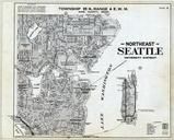 |
Township 25 N., Range 4 E., Seattle - Northeast, University District, Queen |
King County 1936 |
Chas. F. Metsker |
1936 |
 |
Seattle 1960 |
Seattle 1960 |
Chas. F. Metsker |
1960 |
 |
Page 058 - Township 9 N., Range 18 E., Yakima Indian Reservation, Oak Spring, Lousy Creek, Seattle |
Yakima County 1959 |
Metsker Maps |
1959 |
 |
Page B - Street Designations, Seattle Postal Zone Map |
King County 1955 |
Thomas Bros. |
1955 |
 |
Plate 006 - T. 24 N., R. 3 E., Puget Sound, Elliott Bay, West Seattle, Youngstown |
King County 1926 |
Kroll Map Company |
1926 |
 |
Plate 009 - T. 26 N., R. 4 E., Lake Washington, Seattle, Polak, Bart |
King County 1926 |
Kroll Map Company |
1926 |
 |
Plate 012 - T. 23 N., R. 4 E., Lake Washington, Seattle, Rainier Beach |
King County 1926 |
Kroll Map Company |
1926 |
 |
Plate 017 - T. 23 N., R. 5 E., Renton, Seattle, Lake Washington |
King County 1926 |
Kroll Map Company |
1926 |
 |
Plate 032 - T. 21 N., R. 7 E., Palmer Junction, Lake Crow, Green River, Kanasket, Seattle, Franklin |
King County 1926 |
Kroll Map Company |
1926 |
 |
Plate 033 - T. 22 N., R. 7 E., Seattle, Sherwood, Taylor, Halmer |
King County 1926 |
Kroll Map Company |
1926 |
 |
Plate 034 - T. 23 N., R. 7 E., Seattle, Echo Lake, Issaquah Creek |
King County 1926 |
Kroll Map Company |
1926 |
 |
Plate 041 - T. 23 N., R. 8 E., Seattle, Tanner, North Bend |
King County 1926 |
Kroll Map Company |
1926 |
 |
Plate 042 - T. 22 N., R. 8 E., Seattle, Cedar Lake |
King County 1926 |
Kroll Map Company |
1926 |
 |
Plate 043 - T. 21 N., R. 8 E., Seattle, Lemola, Eagle Gorge, Charley Creek |
King County 1926 |
Kroll Map Company |
1926 |
 |
Plate 048 - T. 21 N., R. 9 E., Green River, Seattle, Mt. Lindsay, Cougar Mountain |
King County 1926 |
Kroll Map Company |
1926 |
 |
Plate 049 - T. 22 N., R. 9 E., Seattle, Cedar lake, Snoqualmie National Forest |
King County 1926 |
Kroll Map Company |
1926 |

 Cart
Cart