 |
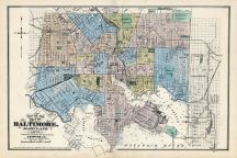
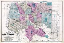
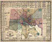
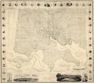
Baltimore |
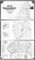
Washington County 1877 |
Lake, Griffing & Stevenson |
1877 |
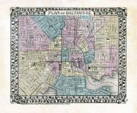 |
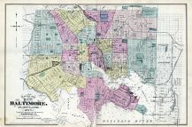
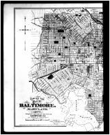
Baltimore - Plan of the City of Washington and Plan of Baltimore Individual Map |
Baltimore 1877 |
US Congress Augustus, Mitchell Jr. |
1870 |
 |
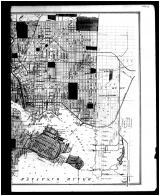
Baltimore City Map 1877 |
Cecil County 1877 |
Lake Griffing & Stevenson |
1877 |
 |
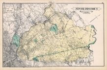
Baltimore County - District 9, Hampden Heights, Govanstown, Towsontown, Hampton, Lutherville |
Baltimore and Howard County 1878 |
G. M. Hopkins |
1878 |
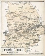 |
Baltimore County - District 4, Owings Mills, Emory Grove, Reisterstown |
Baltimore and Howard County 1878 |
G. M. Hopkins |
1878 |
 |
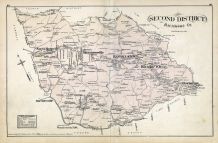
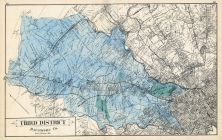
Baltimore County - District 3, Mount Carroll, Arlington, Howardville, Green Springs |
Baltimore and Howard County 1878 |
G. M. Hopkins |
1878 |
 |
Baltimore County - District 2, North Branch, Harrisonville, Randallstown, Rockdale, Powhattan |
Baltimore and Howard County 1878 |
G. M. Hopkins |
1878 |
 |
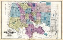
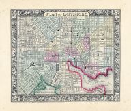
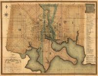
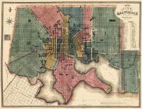
Baltimore City Map |
Baltimore and Howard County 1878 |
G. M. Hopkins |
1878 |
 |
Baltimore County - District 11, Baldwin, Germantown, Kingsville, Upper Falls, Cub Hill |
Baltimore and Howard County 1878 |
G. M. Hopkins |
1878 |
 |
Baltimore County - District 12, East, River Neck, Chesapeake Bay, Bird River, Hawk Cove |
Baltimore and Howard County 1878 |
G. M. Hopkins |
1878 |
 |
Baltimore County - District 12, West, Gardenville, Lavender, Back River, Patapsco River |
Baltimore and Howard County 1878 |
G. M. Hopkins |
1878 |
 |
Baltimore County - Districts 1 and 13, Catonsville, Ulrich, Irvington, Franklin |
Baltimore and Howard County 1878 |
G. M. Hopkins |
1878 |
 |
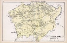
Baltimore County - Districts 8 and 10, Sweet Air, Sunny Brook, Warren, Cockeysville, Gentsville |
Baltimore and Howard County 1878 |
G. M. Hopkins |
1878 |
 |
Baltimore County - Districts 8 and 10, Sweet Air, Sunny Brook, Warren, Cockeysville, Gentsville |
Baltimore and Anne Arundel County 1878 |
G. M. Hopkins |
1878 |
 |
Baltimore County - Districts 1 and 13, Catonsville, Ulrich, Irvington, Franklin |
Baltimore and Anne Arundel County 1878 |
G. M. Hopkins |
1878 |
 |
Baltimore County - District 12, West, Gardenville, Lavender, Back River, Patapsco River |
Baltimore and Anne Arundel County 1878 |
G. M. Hopkins |
1878 |
 |
Baltimore County - District 12, East, River Neck, Chesapeake Bay, Bird River, Hawk Cove |
Baltimore and Anne Arundel County 1878 |
G. M. Hopkins |
1878 |
 |
Baltimore County - District 11, Baldwin, Germantown, Kingsville, Upper Falls, Cub Hill |
Baltimore and Anne Arundel County 1878 |
G. M. Hopkins |
1878 |
 |
Baltimore County - District 9, Hampden Heights, Govanstown, Towsontown, Hampton, Lutherville |
Baltimore and Anne Arundel County 1878 |
G. M. Hopkins |
1878 |
 |
Baltimore County - District 4, Owings Mills, Emory Grove, Reisterstown |
Baltimore and Anne Arundel County 1878 |
G. M. Hopkins |
1878 |
 |
Baltimore County - District 3, Mount Carroll, Arlington, Howardville, Green Springs |
Baltimore and Anne Arundel County 1878 |
G. M. Hopkins |
1878 |
 |
Baltimore County - District 2, North Branch, Harrisonville, Randallstown, Rockdale, Granite, Powhattan |
Baltimore and Anne Arundel County 1878 |
G. M. Hopkins |
1878 |
 |
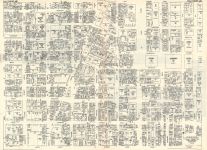
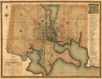
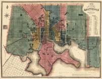
Baltimore City Map |
Baltimore and Anne Arundel County 1878 |
G. M. Hopkins |
1878 |
 |
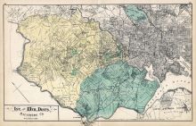
Baltimore |
Wicomico - Somerset - Worcester Counties 1877 |
Lake, Griffing & Stevenson |
1877 |
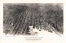 |
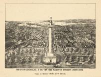
Baltimore 1912 Bird's Eye View 24x36 |
Baltimore 1912 Bird's Eye View |
Edward W. Spofford |
1912 |
 |
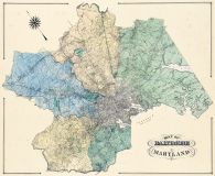
History of Baltimore County 2 |
Baltimore County 1877 |
G. M. Hopkins & Co. |
1877 |
 |
History of Baltimore County 1 |
Baltimore County 1877 |
G. M. Hopkins & Co. |
1877 |
 |
Baltimore |
Maryland 1950c Nirenstein City Maps |
Nirenstein |
1950 |
 |
Baltimore 2 |
Maryland 1950c Nirenstein City Maps |
Nirenstein |
1950 |
 |
Baltimore 1 |
Maryland 1950c Nirenstein City Maps |
Nirenstein |
1950 |
 |
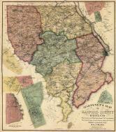
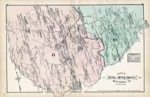
Baltimore City |
Kent and Queen Anne Counties 1877 |
Lake, Griffing and Stevenson |
1877 |
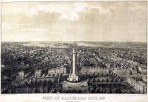 |
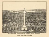
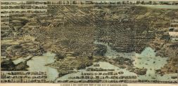
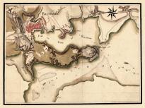
Baltimore 1862c Bird's Eye View 17x24 |
Baltimore 1862c Bird's Eye View |
Sachse and Co. |
1862 |
 |
Baltimore 1878 Composite 24x29 |
Baltimore 1878 Composite |
G. M. Hopkins |
1878 |
 |
Baltimore 1878 Composite 36x44 |
Baltimore 1878 Composite |
G. M. Hopkins |
1878 |
 |
Baltimore 1864 Mitchell Plate |
Baltimore 1864 Mitchell Plate |
S. Augustus Mitchell |
1864 |
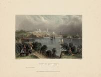 |
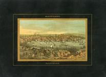
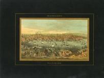
Baltimore 1840 |
Baltimore 1840 View |
W. H. Bartlett |
1840 |
 |
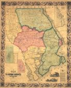
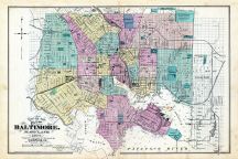
Baltimore City |
Carroll County 1877 |
Lake, Griffing and Stevenson |
1877 |
 |
Index Map - Baltimore City - Right |
Talbot and Dorchester Counties 1877 |
Lake, Griffing, & Stevenson |
1877 |
 |
Index Map - Baltimore City - Left |
Talbot and Dorchester Counties 1877 |
Lake, Griffing, & Stevenson |
1877 |
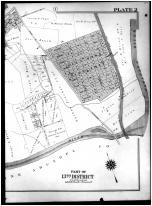 |
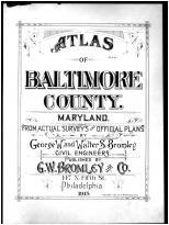
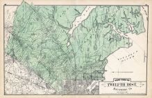
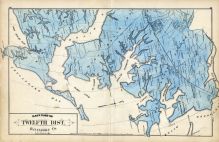
Plate 002 - 13th District, Grosedale, Landsdowne, Baltimore Highlands Right |
Baltimore County 1915 |
G. W. Bromley and Co. |
1915 |
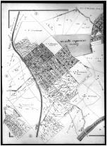 |
Plate 002 - 13th District, Gorsedale, Landsdowne, Baltimore Highlands Left |
Baltimore County 1915 |
G. W. Bromley and Co. |
1915 |
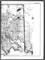 |
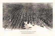
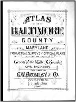
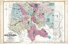
Plate 002 - Baltimore City Right |
Baltimore County 1898 |
G. W. Bromley and Co. |
1898 |
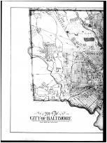 |
Plate 002 - Baltimore City Left |
Baltimore County 1898 |
G. W. Bromley and Co. |
1898 |
 |
Baltimore 1880 Bird's Eye View 24x31 |
Baltimore 1880 Bird's Eye View |
E. Sachse & Co. |
1880 |
 |
Baltimore 1869 Bird's Eye View 24x48 |
Baltimore 1869 Bird's Eye View |
E. Sachse & Co. |
1869 |
 |
Baltimore 1856 Wall Map 44x54 |
Baltimore 1856 Wall Map |
Martenet, Simon J. |
1856 |
 |
Baltimore 1856 Wall Map 36x44 |
Baltimore 1856 Wall Map |
Martenet, Simon J. |
1856 |
 |
Baltimore 1822 27x36 |
Baltimore 1822 |
Lucas, Fielding |
1822 |
 |
Baltimore 1822 24x30 |
Baltimore 1822 |
Lucas, Fielding |
1822 |
 |
Baltimore 1822 17x21 |
Baltimore 1822 |
Lucas, Fielding |
1822 |
 |
Baltimore 1822 Wall Map 38x44 |
Baltimore 1822 Wall Map |
Poppleton, Thomas H. |
1822 |
 |
Baltimore 1822 Wall Map 31x36 |
Baltimore 1822 Wall Map |
Poppleton, Thomas H. |
1822 |
 |
Baltimore 1822 Wall Map 24x26 |
Baltimore 1822 Wall Map |
Poppleton, Thomas H. |
1822 |
 |
Baltimore 1822 Revised 1836 36x46 |
Baltimore 1822 Revised 1836 |
Lucas, Fielding |
1822 |
 |
Baltimore 1822 Revised 1836 24x30 |
Baltimore 1822 Revised 1836 |
Lucas, Fielding |
1822 |
 |
Baltimore 1822 Revised 1836 17x21 |
Baltimore 1822 Revised 1836 |
Lucas, Fielding |
1822 |
 |
Baltimore 1781c 17x22 |
Baltimore 1781c |
Lucas, Fielding |
1781 |
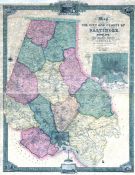 |
Baltimore County 1857 Wall Map 36x46 |
Baltimore County 1857 Wall Map |
Taylor, Robert |
1857 |
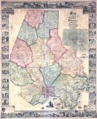 |
Baltimore County 1857 Wall Map with Inserts 44x53 |
Baltimore County 1857 Wall Map with Inserts |
Taylor, Robert |
1857 |
 |
Baltimore 1850 to 1899 Bird's Eye View - 79x258.2 |
Baltimore 1850 to 1899 Bird's Eye View - 79x258.2 |
Charles Magnus |
Unattributed |
 |
Baltimore 1850 to 1899 Bird's Eye View - 95x057.4 |
Baltimore 1850 to 1899 Bird's Eye View - 95x057.4 |
Charles Magnus |
Unattributed |
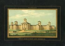 |
Baltimore 1850 to 1899 View of Lunatic Asylum at Spring Grove - 95x057.5 |
Baltimore 1850 to 1899 View of Lunatic Asylum at Spring Grove - 95x057.5 |
Charles Magnus |
Unattributed |

 Cart
Cart