 |
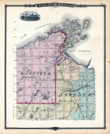
Ashland and Bayfield Counties Map |
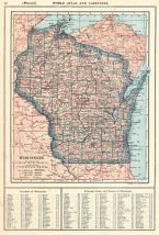
Wisconsin State Atlas 1878 |
Snyder, Van, Vetchem & Co. |
1878 |
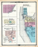 |
Hudson, Bayfield, Barron, River Falls |
Wisconsin State Atlas 1878 |
Snyder, Van, Vetchem & Co. |
1878 |
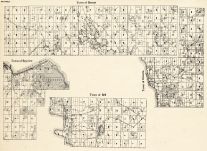 |
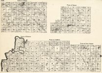
Bayfield County - Barnes, Bayview, Bell, Orienta |
Wisconsin State Atlas 1930c |
W. W. Hixson and Co. |
1930 |
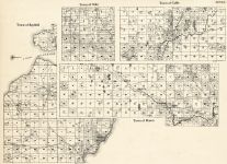 |
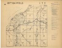
Bayfield County - Bayfield, Oulu, Cable, Mason |
Wisconsin State Atlas 1930c |
W. W. Hixson and Co. |
1930 |
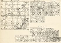 |
Bayfield County - Drummond, Hughes, Tripp, Washburn |
Wisconsin State Atlas 1930c |
W. W. Hixson and Co. |
1930 |
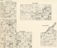 |
Bayfield County - Lincoln, Pilsen, Pratt, Clover |
Wisconsin State Atlas 1930c |
W. W. Hixson and Co. |
1930 |
 |
Bayfield County - Namekagon, Port Wing, Eileen, Russell, Iron River |
Wisconsin State Atlas 1930c |
W. W. Hixson and Co. |
1930 |
 |
Bayfield County Outline - Barksdale, Kelly |
Wisconsin State Atlas 1930c |
W. W. Hixson and Co. |
1930 |
 |
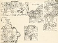
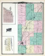
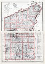
Ashland and Bayfield Counties |
Wisconsin State Atlas 1881 |
H. R. Page |
1881 |
 |
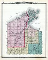
Eau Claire County, Barron, Bayfield |
Wisconsin State Atlas 1881 |
H. R. Page |
1881 |
 |
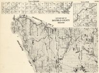
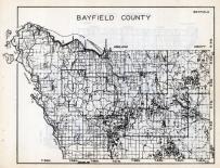
Bayfield County |
Wisconsin State Atlas 1956 Highway Maps |
Wisconsin Highway Commission |
1956 |
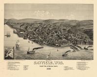 |
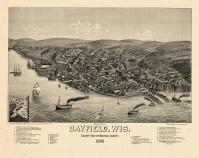
Bayfield 1886 Bird's Eye View 24x30 |
Bayfield 1886 Bird's Eye View |
H. Wellge |
1886 |
 |
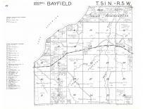
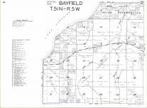
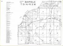
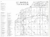
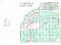
Bayfield T51N-R5W |
Bayfield County 1954 |
Rockford Map Publishers, Inc. |
1954 |
 |
Bayfield T52N-R5W |
Bayfield County 1954 |
Rockford Map Publishers, Inc. |
1954 |
 |
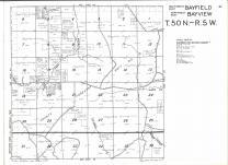
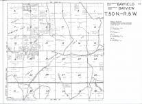
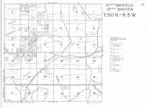
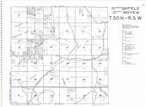
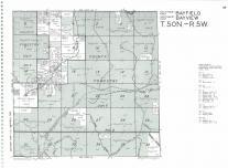
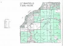
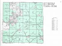
Bayfield, Bayview T50N-R5W |
Bayfield County 1954 |
Rockford Map Publishers, Inc. |
1954 |
 |
Bayfield, Bayview T50N-R5W |
Bayfield County 1960 |
Rockford Map Publishers, Inc. |
1960 |
 |
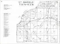
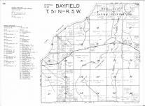
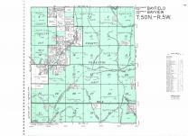
Bayfield T51N-R5W |
Bayfield County 1960 |
Rockford Map Publishers, Inc. |
1960 |
 |
Bayfield, Bayview T50N-R5W |
Bayfield County 1963 |
Rockford Map Publishers, Inc. |
1963 |
 |
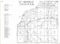
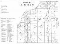
Bayfield T51N-R5W |
Bayfield County 1963 |
Rockford Map Publishers, Inc. |
1963 |
 |
Bayfield, Bayview T50N-R5W |
Bayfield County 1966 |
Rockford Map Publishers, Inc. |
1966 |
 |
Bayfield T51N-R5W |
Bayfield County 1966 |
Rockford Map Publishers, Inc. |
1966 |
 |
Bayfield, Bayview T50N-R5W |
Bayfield County 1969 |
Rockford Map Publishers, Inc. |
1969 |
 |
Bayfield T51N-R5W |
Bayfield County 1969 |
Rockford Map Publishers, Inc. |
1969 |
 |
Bayfield, Bayview T50N-R5W |
Bayfield County 1972 |
Rockford Map Publishers, Inc. |
1972 |
 |
Bayfield T51N-R5W |
Bayfield County 1972 |
Rockford Map Publishers, Inc. |
1972 |
 |
Bayfield T51N-R5W |
Bayfield County 1974 |
Rockford Map Publishers, Inc. |
1974 |
 |
Bayfield, Bayview T50N-R5W |
Bayfield County 1974 |
Rockford Map Publishers, Inc. |
1974 |
 |
Bayfield T51N-R5W |
Bayfield County 1976 |
Rockford Map Publishers, Inc. |
1976 |
 |
Bayfield, Bayview T50N-R5W |
Bayfield County 1976 |
Rockford Map Publishers, Inc. |
1976 |
 |
Bayfield T51N-R5W |
Bayfield County 1978 |
Rockford Map Publishers, Inc. |
1978 |
 |
Bayfield, Bayview T50N-R5W |
Bayfield County 1978 |
Rockford Map Publishers, Inc. |
1978 |
 |
Bayfield T51N-R5W |
Bayfield County 1981 |
Rockford Map Publishers, Inc. |
1981 |
 |
Bayfield, Bayview T50N-R5W |
Bayfield County 1981 |
Rockford Map Publishers, Inc. |
1981 |
 |
Bayfield T51N-R5W |
Bayfield County 1985 |
Rockford Map Publishers, Inc. |
1985 |
 |
Bayfield, Bayview T50N-R5W |
Bayfield County 1985 |
Rockford Map Publishers, Inc. |
1985 |
 |
Bayfield, Bayview T50N-R5W |
Bayfield County 1988 |
Rockford Map Publishers, Inc. |
1988 |
 |
Bayfield T51N-R5W |
Bayfield County 1988 |
Rockford Map Publishers, Inc. |
1988 |
 |
Bayfield T51N-R5W |
Bayfield County 1994 |
Rockford Map Publishers, Inc. |
1994 |
 |
Bayfield, Bayview T50N-R5W |
Bayfield County 1994 |
Rockford Map Publishers, Inc. |
1994 |
 |
Bayfield, Bayview T50N-R5W |
Bayfield County 1996 |
Rockford Map Publishers, Inc. |
1996 |
 |
Bayfield T51N-R5W |
Bayfield County 1996 |
Rockford Map Publishers, Inc. |
1996 |
 |
Bayfield T51N-R5W |
Bayfield County 1998 |
Rockford Map Publishers, Inc. |
1998 |
 |
Bayfield, Bayview T50N-R5W |
Bayfield County 1998 |
Rockford Map Publishers, Inc. |
1998 |
 |
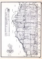
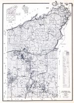
Bayfield County Map |
Wisconsin State Atlas 1933c |
W.W. Hixson & Co. |
1933 |
 |
Bayfield County Map |
Wisconsin State Atlas 1959 |
Thomas O. Nelson Co. |
1959 |
|
|
Bayfield, Bayview T50N-R5W |
Bayfield County 1954 |
Rockford Map Publishers, Inc. |
1954 |
|
|
Bayfield, Bayview T50N-R5W |
Bayfield County 1960 |
Rockford Map Publishers, Inc. |
1960 |
|
|
Bayfield, Bayview T50N-R5W |
Bayfield County 1963 |
Rockford Map Publishers, Inc. |
1963 |
|
|
Bayfield, Bayview T50N-R5W |
Bayfield County 1966 |
Rockford Map Publishers, Inc. |
1966 |
|
|
Bayfield, Bayview T50N-R5W |
Bayfield County 1969 |
Rockford Map Publishers, Inc. |
1969 |
|
|
Bayfield, Bayview T50N-R5W |
Bayfield County 1972 |
Rockford Map Publishers, Inc. |
1972 |
|
|
Bayfield, Bayview T50N-R5W |
Bayfield County 1974 |
Rockford Map Publishers, Inc. |
1974 |
|
|
Bayfield, Bayview T50N-R5W |
Bayfield County 1976 |
Rockford Map Publishers, Inc. |
1976 |
|
|
Bayfield, Bayview T50N-R5W |
Bayfield County 1978 |
Rockford Map Publishers, Inc. |
1978 |
|
|
Bayfield, Bayview T50N-R5W |
Bayfield County 1981 |
Rockford Map Publishers, Inc. |
1981 |
|
|
Bayfield, Bayview T50N-R5W |
Bayfield County 1985 |
Rockford Map Publishers, Inc. |
1985 |
|
|
Bayfield, Bayview T50N-R5W |
Bayfield County 1988 |
Rockford Map Publishers, Inc. |
1988 |
|
|
Bayfield, Bayview T50N-R5W |
Bayfield County 1994 |
Rockford Map Publishers, Inc. |
1994 |
|
|
Bayfield, Bayview T50N-R5W |
Bayfield County 1996 |
Rockford Map Publishers, Inc. |
1996 |
|
|
Bayfield, Bayview T50N-R5W |
Bayfield County 1998 |
Rockford Map Publishers, Inc. |
1998 |
|
|
Bayfield T51N-R5W |
Bayfield County 1954 |
Rockford Map Publishers, Inc. |
1954 |
|
|
Bayfield T51N-R5W |
Bayfield County 1960 |
Rockford Map Publishers, Inc. |
1960 |
|
|
Bayfield T51N-R5W |
Bayfield County 1963 |
Rockford Map Publishers, Inc. |
1963 |
|
|
Bayfield T51N-R5W |
Bayfield County 1966 |
Rockford Map Publishers, Inc. |
1966 |
|
|
Bayfield T51N-R5W |
Bayfield County 1969 |
Rockford Map Publishers, Inc. |
1969 |
|
|
Bayfield T51N-R5W |
Bayfield County 1972 |
Rockford Map Publishers, Inc. |
1972 |
|
|
Bayfield T51N-R5W |
Bayfield County 1974 |
Rockford Map Publishers, Inc. |
1974 |
|
|
Bayfield T51N-R5W |
Bayfield County 1976 |
Rockford Map Publishers, Inc. |
1976 |
|
|
Bayfield T51N-R5W |
Bayfield County 1978 |
Rockford Map Publishers, Inc. |
1978 |
|
|
Bayfield T51N-R5W |
Bayfield County 1981 |
Rockford Map Publishers, Inc. |
1981 |
|
|
Bayfield T51N-R5W |
Bayfield County 1985 |
Rockford Map Publishers, Inc. |
1985 |
|
|
Bayfield T51N-R5W |
Bayfield County 1988 |
Rockford Map Publishers, Inc. |
1988 |
|
|
Bayfield T51N-R5W |
Bayfield County 1994 |
Rockford Map Publishers, Inc. |
1994 |
|
|
Bayfield T51N-R5W |
Bayfield County 1996 |
Rockford Map Publishers, Inc. |
1996 |
|
|
Bayfield T51N-R5W |
Bayfield County 1998 |
Rockford Map Publishers, Inc. |
1998 |
|
|
Bayfield T52N-R5W |
Bayfield County 1954 |
Rockford Map Publishers, Inc. |
1954 |

 Cart
Cart