|
Spokane City - Page 043 - Section 017 |
Spokane County 1912 |
Geo A. Ogle |
1912 |
 |
Spokane City - Page 042 - Section 020 |
Spokane County 1912 |
Geo A. Ogle |
1912 |
 |
Spokane City - Page 041 - Section 029 |
Spokane County 1912 |
Geo A. Ogle |
1912 |
 |
Spokane City - Page 040 - Section 032, Section 031 - Part, Washington Heights |
Spokane County 1912 |
Geo A. Ogle |
1912 |
 |
Spokane City - Page 039 - Section 033 2 |
Spokane County 1912 |
Geo A. Ogle |
1912 |
 |
Spokane City - Page 038 - Section 028 2 |
Spokane County 1912 |
Geo A. Ogle |
1912 |
 |
Spokane City - Page 037 - Section 021 |
Spokane County 1912 |
Geo A. Ogle |
1912 |
 |
Spokane City - Page 036 - Section 016 |
Spokane County 1912 |
Geo A. Ogle |
1912 |
 |
Spokane City - Page 035 - Section 035, Section 34 - East |
Spokane County 1912 |
Geo A. Ogle |
1912 |
 |
Spokane City - Page 035 - Section 009 |
Spokane County 1912 |
Geo A. Ogle |
1912 |
 |
Spokane City - Page 034 - Section 004 |
Spokane County 1912 |
Geo A. Ogle |
1912 |
 |
Spokane City - Page 033 - Section 033 1 |
Spokane County 1912 |
Geo A. Ogle |
1912 |
 |
Spokane City - Page 032 - Section 028 1, Section 030 - South |
Spokane County 1912 |
Geo A. Ogle |
1912 |
 |
Spokane City - Page 031 - Section 027 2, Section 035 - Part, Montesano |
Spokane County 1912 |
Geo A. Ogle |
1912 |
 |
Spokane City - Page 030 - Section 034 2 |
Spokane County 1912 |
Geo A. Ogle |
1912 |
 |
Spokane City - Page 029 - Section 003 |
Spokane County 1912 |
Geo A. Ogle |
1912 |
 |
Spokane City - Page 028 - Section 010 |
Spokane County 1912 |
Geo A. Ogle |
1912 |
 |
Spokane City - Page 027 - Section 015 1 |
Spokane County 1912 |
Geo A. Ogle |
1912 |
 |
Spokane City - Page 026 - Section 022 |
Spokane County 1912 |
Geo A. Ogle |
1912 |
 |
Spokane City - Page 025 - Section 027 1 |
Spokane County 1912 |
Geo A. Ogle |
1912 |
 |
Spokane City - Page 024 - Section 034 1 |
Spokane County 1912 |
Geo A. Ogle |
1912 |
 |
Spokane City - Page 023 - Section 026 1, Section 035 North |
Spokane County 1912 |
Geo A. Ogle |
1912 |
 |
Spokane City - Page 022 - Section 023 |
Spokane County 1912 |
Geo A. Ogle |
1912 |
 |
Spokane City - Page 021 - Section 014 |
Spokane County 1912 |
Geo A. Ogle |
1912 |
 |
Spokane City - Page 020 - Section 013 1 |
Spokane County 1912 |
Geo A. Ogle |
1912 |
 |
Spokane City - Page 019 - Section 024 1 |
Spokane County 1912 |
Geo A. Ogle |
1912 |
 |
Page 94, Brighton Beach, Manhattan Beach, Spokane Country Club Tracts |
Spokane County 1912 |
Geo A. Ogle |
1912 |
 |
Page 132, Greenacres, Irrigation District, Dreamwood, Spokane Bridge |
Spokane County 1912 |
Geo A. Ogle |
1912 |
 |
Index Map - Spokane City 2, Outline County Map |
Spokane County 1912 |
Geo A. Ogle |
1912 |
 |
Index Map - Spokane City 1, Index Map - County |
Spokane County 1912 |
Geo A. Ogle |
1912 |
 |
Spokane City - Page 062 - Section 015 2, Section 022 - Part |
Spokane County 1912 |
Geo A. Ogle |
1912 |
 |
Spokane City - Page 063 - Section 027 - North, Castle Hill, Laura Lee Add., Pasadena Add. |
Spokane County 1912 |
Geo A. Ogle |
1912 |
 |
Spokane City - Page 059 - Section 002 |
Spokane County 1912 |
Geo A. Ogle |
1912 |
 |
Spokane City - Page 060 - Section 026 2 |
Spokane County 1912 |
Geo A. Ogle |
1912 |
 |
Spokane City - Page 057 - Section 001 |
Spokane County 1912 |
Geo A. Ogle |
1912 |
 |
Spokane City - Page 058 - Section 036 - South, Section 035 - South, West Hiawatha |
Spokane County 1912 |
Geo A. Ogle |
1912 |
 |
Spokane City - Page 056 - Section 012 |
Spokane County 1912 |
Geo A. Ogle |
1912 |
 |
Spokane City - Page 055 - Section 013 2, Section 014 - Part, Section 011 Part |
Spokane County 1912 |
Geo A. Ogle |
1912 |
 |
Spokane City - Page 054 - Section 024 2, Section 23 - Part, Section 14 - Part |
Spokane County 1912 |
Geo A. Ogle |
1912 |
 |
Spokane City - Page 053 - Section 025 |
Spokane County 1912 |
Geo A. Ogle |
1912 |
 |
Spokane City - Page 052 - Section 030 |
Spokane County 1912 |
Geo A. Ogle |
1912 |
 |
Spokane City - Page 049 - Section 007 |
Spokane County 1912 |
Geo A. Ogle |
1912 |
 |
Spokane City - Page 050 - Section 018 |
Spokane County 1912 |
Geo A. Ogle |
1912 |
 |
Spokane City - Page 051 - Section 019 |
Spokane County 1912 |
Geo A. Ogle |
1912 |
 |
Spokane City - Page 047 - Section 031 |
Spokane County 1912 |
Geo A. Ogle |
1912 |
 |
Spokane City - Page 048 - Section 006 |
Spokane County 1912 |
Geo A. Ogle |
1912 |
 |
Spokane City - Page 045 - Section 005 |
Spokane County 1912 |
Geo A. Ogle |
1912 |
 |
Spokane City - Page 044 - Section 008 |
Spokane County 1912 |
Geo A. Ogle |
1912 |
 |
Office of Spokane Valley Irrigated Land, Wichmann Residence, Howard Residence, Zehm Residence |
Spokane County 1912 |
Geo A. Ogle |
1912 |
 |
Haworth Dental Parlors, Rockland Jersey Farm, Spokane Seed Co, Hillyard State Bank |
Spokane County 1912 |
Geo A. Ogle |
1912 |
 |
Page 080 - Wild Rose Prairie, Spokane River, McKay Hill, Wayside |
Stevens County 1963 |
Thos. C. Metsker |
1963 |
 |
Page 054 - Spokane Indian Reservation, Walkers Prairie, Lyons Hill, Chamokane Creek |
Stevens County 1963 |
Thos. C. Metsker |
1963 |
 |
Page 053 - Spokane Indian Reservation, Ford, Prairie, Becks Hill |
Stevens County 1963 |
Thos. C. Metsker |
1963 |
 |
Page 040 - Spokane Indian Reservation, Camas Prairie, Lyons Hills, Camas Creek |
Stevens County 1963 |
Thos. C. Metsker |
1963 |
 |
Page 039 - Spokane Indian Reservation, Cottonwood Creek, Chamokane Creek, Sams Creek |
Stevens County 1963 |
Thos. C. Metsker |
1963 |
 |
Page 038 - Little Falls, Long Lake, Spokane Indian Reservation, Chamokane Creek |
Stevens County 1963 |
Thos. C. Metsker |
1963 |
 |
Page 026 - Spokane Indian Reservation, Deer Mountain, Huckleberry Mountains, Blue Mountain, Camas Creek, Sand Creek |
Stevens County 1963 |
Thos. C. Metsker |
1963 |
 |
Page 025 - Spokane Indian Reservation, Wellpinit, Turtle Lake, Little Chemokane Creek |
Stevens County 1963 |
Thos. C. Metsker |
1963 |
 |
Page 024 - Spokane Indian Reservation, Franklin d. Roosevelt Lake, Coulee Dam, Benjamin Lake, Cayuse Mountain |
Stevens County 1963 |
Thos. C. Metsker |
1963 |
 |
Page 012 - Spokane Indian Reservation, Orazada Creek, O-Ra-Pak-En Creek, Boundary Butte |
Stevens County 1963 |
Thos. C. Metsker |
1963 |
 |
Page 011 - Franklin D. Roosevelt Lake, Coulee Dam, Spokane Indian Reservation |
Stevens County 1963 |
Thos. C. Metsker |
1963 |
 |
Page 010 - Spokane Indian Reservation, Spokane River, Franklin D. Roosevelt Lake |
Stevens County 1963 |
Thos. C. Metsker |
1963 |
 |
Page 005 - Spokane Indian Reservation, Franklin D. Roosevelt Lake, Coulee Dam, Fort Spokane, Miles |
Stevens County 1963 |
Thos. C. Metsker |
1963 |
 |
Page 006 - Spokane Indian Reserrvation, Enterprise, Mudgett Lake, McCoy Lake, Franklin D. Roosevelt Lake, Miller Mountain |
Stevens County 1963 |
Thos. C. Metsker |
1963 |
 |
Page 004 - Colville Indian Reservation, Franklin D. Rossevelt Lake, Little Ninemile Creek Sesotel, Creek, Spokane Indian Reservation, Castle Rock Creek |
Stevens County 1963 |
Thos. C. Metsker |
1963 |
 |
Spokane 1905 Bird's Eye View 17x25 |
Spokane 1905 Bird's Eye View |
John W. Graham & Co. |
1905 |
 |
Page 035 - Tweedie, Scotia, Spokane River |
Pend Oreille County 1941 |
Chas. F. Metsker |
1941 |
 |
Page 036 - Penrith, Newport, Pend Oreille River, Little Spokane River |
Pend Oreille County 1941 |
Chas. F. Metsker |
1941 |
 |
Township 25 N Range 42 E, Spokane |
Spokane County 1905 |
Fidelity Abstract Co. |
1905 |
 |
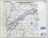
Township 25 N Range 43 E, Spokane |
Spokane County 1905 |
Fidelity Abstract Co. |
1905 |
 |
Township 25 N., Range 43 E., Spokane, Pantops, Glenrose, Pine Frove, Felts Field |
Spokane County 1950 |
Metsker Maps |
1950 |
 |
Township 26 N., Range 42 E., Seven Mile, Riverside State Park, Little Spokane River |
Spokane County 1950 |
Metsker Maps |
1950 |
 |
Township 26 N., Range 43 E., Spokane, Hillyard, Dartford |
Spokane County 1950 |
Metsker Maps |
1950 |
 |
Township 27 N., Range 44 E., Peone, Breen Bluff, Mount Spokane State Park |
Spokane County 1950 |
Metsker Maps |
1950 |
 |
Township 27 N., Range 45 and 46 E., Newman Lake, Mount Spokane State Park |
Spokane County 1950 |
Metsker Maps |
1950 |
 |
Township 28 N., Range 43 E., Shattaroy Station, Little Spokane River |
Spokane County 1950 |
Metsker Maps |
1950 |
 |
Township 28 N., Range 44 E., Mount Spokane State Park, Cottonwood Creek |
Spokane County 1950 |
Metsker Maps |
1950 |
 |
Township 28 N., Range 45 and 46 E., Mount Spokane State Park, White Pine Ridge |
Spokane County 1950 |
Metsker Maps |
1950 |
 |
Township 29 N., Range 44 E., Little Spokane River, Elk |
Spokane County 1950 |
Metsker Maps |
1950 |
 |
Township 29 N., Range 45 and 46 E., Mount Spokane State Park, Blanchard Valley |
Spokane County 1950 |
Metsker Maps |
1950 |
 |
Township 30 N., Range 43 E., Pend Oreille State Park, Trout Lake, Spokane River |
Pend Oreille County 1957 |
Metsker Maps |
1957 |
 |
Township 30 N., Range 44 E., Diamond Lake, Spokane River |
Pend Oreille County 1957 |
Metsker Maps |
1957 |
 |
Township 30 N., Range 45 E., Little Spokane river, Scotia, Tweedie |
Pend Oreille County 1957 |
Metsker Maps |
1957 |
 |
Spokane County 1980 to 1996 Mylar |
Spokane County 1980 to 1996 |
Metsker Maps |
1980 |
 |
Spokane County 1980 to 1996 Tracing |
Spokane County 1980 to 1996 |
Metsker Maps |
1980 |
 |
Page 043 - Township 29 N. Range 35 E., Colville Indian Reservation, Spokane Indian Res. |
Ferry County 1934 |
Metsker Maps |
1934 |
 |
Page 049 - Township 28 N., Range 36 E., Fort Spokane, Miles, Roosevelt Lake |
Lincoln County 1960 |
Metsker Maps |
1960 |
 |
Page 056 - Township 27 N., Range 37 E., Spokane River, Green Canyon |
Lincoln County 1960 |
Metsker Maps |
1960 |
 |
Page 071 - Township 27 N., Range 39 E., Little Falls, Long Lake, Spokane River, Chamokane Cr. |
Lincoln County 1960 |
Metsker Maps |
1960 |
 |
Page 016 - Township 27 N., Range 41 E., Spokane River, Four Mound Prairie, Knight Lake |
Spokane County 1984 |
Metsker Maps |
1984 |
 |
Page 022 - Township 26 N., Range 42 E., Spokane River, Nine Mile, Seven Mile, Riverside State Park |
Spokane County 1984 |
Metsker Maps |
1984 |
 |
Page 030 - Township 25 N., Range 43 E., Spokane City, Felts Field, Park Water, Pantops, Glenrose |
Spokane County 1984 |
Metsker Maps |
1984 |
 |
Page 031 - Township 26 N., Range 43 E., Spokane City, Hillyard, Deadman Creek, Mead, Dartford |
Spokane County 1984 |
Metsker Maps |
1984 |
 |
Page 033 - Township 28 N., Range 43 E., Chattaroy, Spokane River, Dragoon Creek |
Spokane County 1984 |
Metsker Maps |
1984 |
 |
Page 034 - Township 29 N., Range 43 E., Eloika Lake, Deer Park Numicipal Airport, Milan, Spokane river |
Spokane County 1984 |
Metsker Maps |
1984 |
 |
Page 041 - Township 27 N., Range 44 E., Peone, Deanman Creek, Mount Spokane State Park, Green Bluff |
Spokane County 1984 |
Metsker Maps |
1984 |
 |
Page 042 - Township 28 N., Range 44 E., Mount Spokane State Park, Little Deer Creek, Missouri Ridge |
Spokane County 1984 |
Metsker Maps |
1984 |
 |
Page 043 - Township 29 N., Range 44 E., Elk, Reflection Creek, Mount Spokane State Park |
Spokane County 1984 |
Metsker Maps |
1984 |
 |
Page 050 - Township 27 N., Range 45 and 46 E., Newman Lake, Mount Spokane State Park, Deadman Creek |
Spokane County 1984 |
Metsker Maps |
1984 |
 |
Page 051 - Township 28 N., Range 45 and 46 E., Mount Spokane State Park, Brickel Creek |
Spokane County 1984 |
Metsker Maps |
1984 |
 |
Page 052 - Township 29 N., Range 45 and 46 E., Mount Spokane State Park, Blanchard Valley |
Spokane County 1984 |
Metsker Maps |
1984 |
 |
Page 004 - Township 29 N. Range 35 E., Colville Indian Reservation, Spokane Indian Res. |
Stevens County 1973 |
Metsker Maps |
1973 |
 |
Page 005 - Township 28 N. Range 36 E., Fort Spokane, Miles, Lilienthal Mtn. |
Stevens County 1973 |
Metsker Maps |
1973 |
 |
Page 010 - Township 27 N. Range 37 E., Spokane River, Green Canyon |
Stevens County 1973 |
Metsker Maps |
1973 |
 |
Page 011 - Township 28 N. Range 37 E., Franklin D. Roosevelt Lake, Spokane Mtn., Orazada Cr. |
Stevens County 1973 |
Metsker Maps |
1973 |
 |
Page 024 - Township 27 N. Range 38 E., Spokane Indian Reservation, Franklin D. Roosevelt Lake |
Stevens County 1973 |
Metsker Maps |
1973 |
 |
Page 038 - Township 27 N. Range 39 E., Long Lake, Little Falls, Spokane Indian Reservation |
Stevens County 1973 |
Metsker Maps |
1973 |
 |
Page 066 - Township 27 N. Range 41 E., Spokane River, Four Mound Prairie, Knight Lake |
Stevens County 1973 |
Metsker Maps |
1973 |
|
|
Township 25 N Range 43 E, Spokane |
Spokane County 1905 |
Fidelity Abstract Co. |
1905 |
|
|
Township 25 N., Range 43 E., Spokane, Pantops, Glenrose, Pine Frove, Felts Field |
Spokane County 1950 |
Metsker Maps |
1950 |
|
|
Page 030 - Township 25 N., Range 43 E., Spokane City, Felts Field, Park Water, Pantops, Glenrose |
Spokane County 1984 |
Metsker Maps |
1984 |

 Cart
Cart