
 Cart
CartAddress Search
Results for "Latitude 48.589854, Longitude -98.379456"
View these maps overlayed on top of a modern map. You must be a member and logged in to use this feature.
Purchase a series of maps or images documenting the environmental or land use history of this location.
 A variety of printed products can be purchased by clicking on each individual map in the results below.
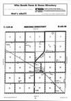
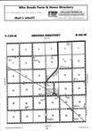
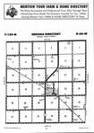
Click on any of the maps below to view a large, zoomable map.
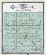 |
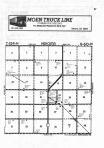
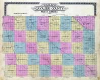
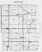
Nekoma Township Cavalier County 1912 show address on this map |
Geo. A. Ogle & Co. | 1912 |
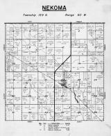 |
Nekoma Township Cavalier County 1954 show address on this map |
Pioneer Atlas Minnesota | 1954 |
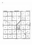 |
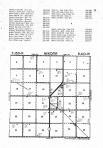
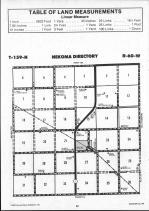
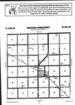
Nekoma T159N-R60W Cavalier County 1976 show address on this map |
Directory Service Company | 1976 |
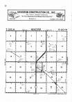 |
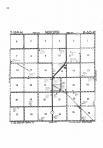
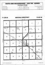
Nekoma T159N-R60W Cavalier County 1977 show address on this map |
Directory Service Company | 1977 |
 |
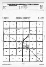
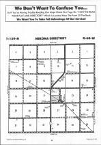
Nekoma T159N-R60W Cavalier County 1978 show address on this map |
Directory Service Company | 1978 |
 |
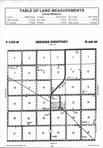
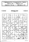
Nekoma T159N-R60W Cavalier County 1980 show address on this map |
Directory Service Company | 1980 |
 |
Nekoma T159N-R60W Cavalier County 1984 show address on this map |
Directory Service Company | 1984 |
 |
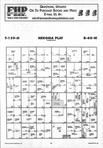
Nekoma T159N-R60W Cavalier County 1988 show address on this map |
Farm and Home Publishers, LTD | 1988 |
 |
Nekoma T159N-R60W Cavalier County 1990 show address on this map |
Farm and Home Publishers, LTD | 1990 |
 |
Nekoma T159N-R60W Cavalier County 1991 show address on this map |
Farm and Home Publishers, LTD | 1991 |
 |
Nekoma T159N-R60W Cavalier County 1992 show address on this map |
Farm and Home Publishers, LTD | 1992 |
 |
Nekoma T159N-R60W Cavalier County 1994 show address on this map |
Farm and Home Publishers, LTD | 1994 |
 |
Nekoma T159N-R60W Cavalier County 1995 show address on this map |
Farm and Home Publishers, LTD | 1995 |
 |
Nekoma T159N-R60W Cavalier County 1996 show address on this map |
Farm and Home Publishers, LTD | 1996 |
 |
Nekoma T159N-R60W Cavalier County 1997 show address on this map |
Farm and Home Publishers, LTD | 1997 |
 |
Nekoma T159N-R60W Cavalier County 1998 show address on this map |
Farm and Home Publishers, LTD | 1998 |
 |
Nekoma T159N-R60W Cavalier County 1999 show address on this map |
Farm and Home Publishers, LTD | 1999 |
 |
Nekoma T159N-R60W Cavalier County 2000 show address on this map |
Farm and Home Publishers, LTD | 2000 |
 |
Nekoma T159N-R60W Cavalier County 2001 show address on this map |
Farm and Home Publishers, LTD | 2001 |
 |
Nekoma T159N-R60W Cavalier County 2002 show address on this map |
Farm and Home Publishers, LTD | 2002 |
 |
Nekoma T159N-R60W Cavalier County 2004 show address on this map |
Farm and Home Publishers, LTD | 2004 |
 |
Nekoma T159N-R60W Cavalier County 2005 show address on this map |
Farm and Home Publishers, LTD | 2005 |
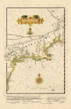 |
Eastern Seaboard Chart 1616 Reprinted in 1841 Virginia to Maine Eastern Seaboard Chart 1616 Reprinted in 1841 Virginia to Maine show address on this map |
Royal Archives of the Hague | 1841 |
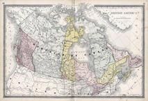 |
British America Wells County 1881 show address on this map |
H.H. Hardesty | 1881 |
 |
United States Map Winnebago County and Boone County 1886 show address on this map |
H. R. Page & Co. | 1886 |
 |
Land Survey of the United States Cass County 1893 show address on this map |
D.W. Ensign & Co. | 1893 |
 |
The World Map with Principal Cities of the Old World Fillmore County 1896 show address on this map |
Geo. A. Ogle & Co. | 1896 |
 |
United States Map Genesee County 1899 show address on this map |
Homer A. Day | 1899 |
 |
World Map Rooks County 1904 to 1905 show address on this map |
Geo. A. Ogle & Co. | 1904 |
 |
United States Map Waushara County 1906c show address on this map |
C.A. McIntyre and C.H. Terril | 1906c |
 |
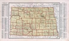
Cavalier County Outline Map Cavalier County 1912 show address on this map |
Geo. A. Ogle & Co. | 1912 |
 |
World Map Guthrie County 1917c show address on this map |
Kenyon Company | 1917c |
 |
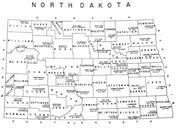
North Dakota State Map Pembina County 1928 show address on this map |
Brock & Company | 1928 |
 |
Minnesota State Map Yellow Medicine County 1929 show address on this map |
Webb Publishing Co. | 1929 |
 |
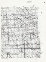
Cavalier County Map 2 Cavalier County 1954 show address on this map |
Pioneer Atlas Minnesota | 1954 |
 |
North Dakota State Map Stutsman County 1958 show address on this map |
Thomas O. Nelson Co. | 1958 |
 |
North Dakota State Map Towner County 1959 show address on this map |
Thomas O. Nelson Co. | 1959 |
 |
Cavalier County 2 North Dakota State Atlas 1961 show address on this map |
Thomas O. Nelson Co. | 1961 |