
 Cart
CartAddress Search
Results for "Latitude 43.6573834, Longitude -70.3116055"
View these maps overlayed on top of a modern map. You must be a member and logged in to use this feature.
Purchase a series of maps or images documenting the environmental or land use history of this location.
 A variety of printed products can be purchased by clicking on each individual map in the results below.
Click on any of the maps below to view a large, zoomable map.
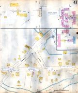 |
Plate 042 Portland 1909 Vol 2 Revised 1951 show address on this map |
Sanborn Map Company | 1909 |
 |
Portland Development Composite 1720 to 1856 17x55 Portland Development Composite 1720 to 1856 show address on this map |
Various | 1720 |
 |
Westbrook 1850 to 1886 Wall Map Westbrook 1850 to 1886 show address on this map |
Provided by City of Westbrook | 1850 |
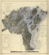 |
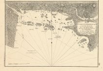
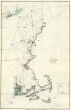
Portland Harbor Chart 1862 Maine - Hand Colored by John R. Barrows Version 3 Portland Harbor Chart 1862 Maine - Hand Colored by John R. Barrows show address on this map |
A. D. Bache U. S. Coast Survey | 1862 |
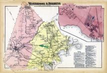 |
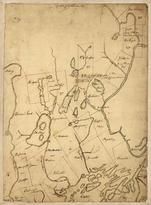
Westbrook and Deering, East Deering, Deering East Cumberland County 1871 show address on this map |
F. W. Beers & Co. | 1871 |
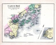 |
Casco Bay, Scarborough, Cape Elizabeth, Portland, Falmouth, Cumberland, Yarmouth, Freeport, Peaks Island Maine State Atlas 1884 show address on this map |
Geo N. Colby & Co. | 1884 |
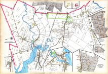 |
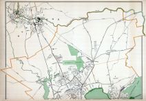
Plate 010 Portland and South Portland Cities 1914 show address on this map |
Richards Map Company | 1914 |
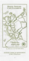 |
Page 024 - Roads Around Cape Elizabeth Map Portland 1955 Hay's Guide to Portland and Motoring in Maine show address on this map |
Hay's Drug Stores | 1955 |
 |
Westbrook - Portland - Deering - Stroudwater 19xx Westbrook - Portland - Deering - Stroudwater 19xx show address on this map |
Unattributed | 19xx |
 |
Maine 1754 Coast and Rivers MHS Digital Image 2731 Maine 1754 Coast and Rivers MHS Digital Image 2731 show address on this map |
Thomas Johnston | 1754 |
 |
Cumberland and Oxford Counties 1771c Cumberland and Oxford Counties 1771c show address on this map |
Greenleaf, S., Captain | 1771c |
 |
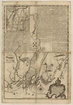
Casco Bay Chart 1776 Casco Bay Chart 1776 show address on this map |
Des Barres, Joseph F.W. | 1776 |
 |
Casco Bay 1779 Plan de la baie et du havre de Casco et des ?les adjacentes Casco Bay 1779 Plan de la baie et du havre de Casco et des iles adjacentes show address on this map |
Cyprian Southack | 1779 |
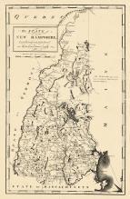 |
New Hampshire State Map 1794 New Hampshire State Map 1794 show address on this map |
Samuel Lewis | 1794 |
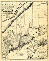 |
Sullivan's District Map of Maine 1795 Sullivan's District Map of Maine 1795 show address on this map |
Sullivan | 1795 |
 |
Maine State Map 1799c MHS Digital Image 5103 Maine State Map 1799c MHS Digital Image 5103 show address on this map |
Osgood Carleton | 1799c |
 |
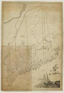
Maine State Map 182x Maine State Map 182x show address on this map |
Perkins, A.T. | 182x |
 |
Maine to Rhode Island 1851 Coast Survey Chart Maine to Rhode Island 1851 Coast Survey Chart show address on this map |
A. D. Bache Superintendent | 1851 |
 |
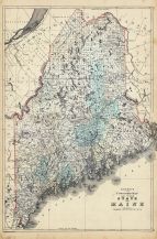
Maine State Map 1855 Wall Map Maine State Map 1855 Wall Map show address on this map |
J. B. Mansfield | 1855 |
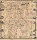 |
York County 1856 Wall Map York County 1856 Wall Map show address on this map |
J.L. Smith & Co. | 1856 |
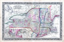 |
New York, New Hampshire, Vermont 1864 Mitchell Plate New York, New Hampshire, Vermont 1864 Mitchell Plate show address on this map |
S. Augustus Mitchell | 1864 |
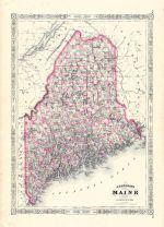 |
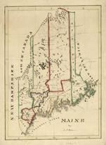
Maine State Map 1866 Maine State Map 1866 show address on this map |
A. J. Johnson | 1866 |
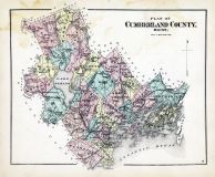 |
Cumberland County Cumberland County 1871 show address on this map |
F. W. Beers & Co. | 1871 |
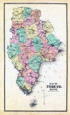 |
York County York County 1872 show address on this map |
Sanford, Everts and Co. | 1872 |
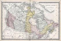 |
British America Wells County 1881 show address on this map |
H.H. Hardesty | 1881 |
 |
St. Croix and Hudson Rivers and Lake Ontario Chart 1882 New England St. Croix and Hudson River and Lake Ontario Chart 1882 New England show address on this map |
U. S. Coastal Survey | 1882 |
 |
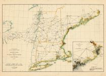
New England 1883 New England 1883 show address on this map |
Van Antwerp Bragg and Co. | 1883 |
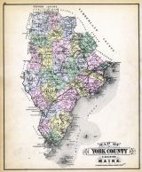 |
York County Map Maine State Atlas 1884 show address on this map |
Geo N. Colby & Co. | 1884 |
 |
United States Map Winnebago County and Boone County 1886 show address on this map |
H. R. Page & Co. | 1886 |
 |
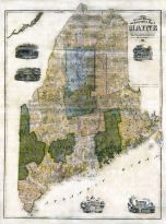
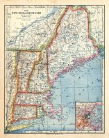
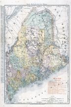
Maine 1887 County and Township Map Maine 1887 County and Township Map show address on this map |
M. Bradley and Bros. | 1887 |
 |
Land Survey of the United States Cass County 1893 show address on this map |
D.W. Ensign & Co. | 1893 |
 |
The World Map with Principal Cities of the Old World Fillmore County 1896 show address on this map |
Geo. A. Ogle & Co. | 1896 |
 |
United States Map Genesee County 1899 show address on this map |
Homer A. Day | 1899 |
 |
World Map Rooks County 1904 to 1905 show address on this map |
Geo. A. Ogle & Co. | 1904 |
 |
Maine Railroad Map 1906 Maine Railroad Map 1906 show address on this map |
Rand-McNally | 1906 |
 |
United States Map Waushara County 1906c show address on this map |
C.A. McIntyre and C.H. Terril | 1906c |
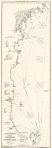 |
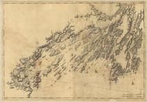
Gloucester to Kennebec River Chart E 1909 Revised 1913 Eldridge Gloucester to Kennebec River Chart E 1909 Revised 1913 Eldridge show address on this map |
Geo. E. Eldridge | 1913 |
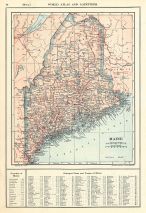 |
Maine State Map 1908 Revised 1914 Maine State Map 1908 Revised 1914 show address on this map |
L. L. Poates | 1914 |
 |
World Map Guthrie County 1917c show address on this map |
Kenyon Company | 1917c |
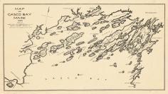 |
Casco Bay 1923 from Casco Bay 1923 - 1924 Directory Casco Bay 1923 from Casco Bay 1923 - 1924 Directory show address on this map |
Crowley and Lunt, Publishers | 1924 |