Click on any of the maps below to view a large, zoomable map.
 |
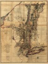
Wynantskill, Grafton, Defreestville, Grafton Center
Rensselaer County 1876
show address on this map
|
F. W. Beers & Co. |
1876 |
 |
Plate 025, Berkshire, Williamstown, Clarksburg, Windsor, Hancock
Massachusetts State Atlas 1891
show address on this map
|
Geo. H. Walker & Co. |
1891 |
 |
Plate 025 - Lanesborough, Cheshire, Ashford, Williamstown, North Adams
Massachusetts State Atlas 1900
show address on this map
|
Geo. H. Walker & Co. |
1900 |
 |
Plate 025 - Lanesborough, Sheshire, Dalton, Williamstown, North Adams, Clarksburg
Massachusetts State Atlas 1904
show address on this map
|
Geo. H. Walker & Co. |
1904 |
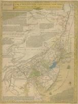 |
Pennsylvania, New Jersey, New York, Delaware 1749 - APSdigobj3524
Pennsylvania, New Jersey, New York, Delaware 1749
show address on this map
|
Evans, Lewis, 1700?-1756 |
1749 |
 |
Hudson River from Albany to Fort Edward 1758c
Hudson River from Albany to Fort Edward 1758c
show address on this map
|
Unattributed |
1758c |
 |
Lake Champlain 1776 MHS Digital Image 2732
Lake Champlain 1776 MHS Digital Image 2732
show address on this map
|
William Brasier |
1776 |
 |
Berkshire County 1777 MHS Digital Image 5089
Berkshire County 1777 MHS Digital Image 5089
show address on this map
|
Wendell family |
1777 |
 |
New York Province 1779 Land Tracts new
New York Province 1779 Land Tracts
show address on this map
|
Claude Joseph Sauthier |
1779 |
 |
Massachusetts 1785c MHS Digital Image 5091
Massachusetts 1785c MHS Digital Image 5091
show address on this map
|
Wendall family |
1785c |
 |
Vermont 1789 MHS Digital Image 3606
Vermont 1789 MHS Digital Image 3606
show address on this map
|
Amos Doolittle, New Haven, Conn. |
1789 |
 |
Pennsylvania 1791c - APSdigobj3529
Pennsylvania 1791c
show address on this map
|
Adlum, John, 1759-1836; Wallis, John |
1791c |
 |
Massachusetts 1802 MHS Digital Image 2113
Massachusetts 1802 MHS Digital Image 2113
show address on this map
|
Osgood Carleton |
1802 |
 |
Pennsylvania 1807 including neighboring states - APSdigobj3463
Pennsylvania 1807 including neighboring states
show address on this map
|
Pursh, Frederick, 1774-1820 |
1807 |
 |
Vermont 1814 State Map 17x21
Vermont 1814 State Map
show address on this map
|
Carey, Mathew |
1814 |
 |
Vermont 181x State Map 17x20
Vermont 181x State Map
show address on this map
|
Doolittle, Amos |
181x |
 |
Vermont 1826 State Map 17x20
Vermont 1826 State Map
show address on this map
|
Lucas Fielding |
1826 |
 |
Massachusetts and Rhode Island 1850 MHS Digital Image 5155
Massachusetts and Rhode Island 1850 MHS Digital Image 5155
show address on this map
|
Unattributed |
1850 |
 |
Lake Ontario - Lake Erie - Lake Champlain 1861 Lighthouse Charts - APSdigobj3543_002
Lake Ontario - Lake Erie - Lake Champlain 1861 Lighthouse Charts
show address on this map
|
Meade, George Gordon, 1815-1872 |
1861 |
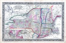 |
New York, New Hampshire, Vermont 1864 Mitchell Plate
New York, New Hampshire, Vermont 1864 Mitchell Plate
show address on this map
|
S. Augustus Mitchell |
1864 |
 |
Washington County Map
Washington County 1866
show address on this map
|
Stone and Stewart |
1866 |
 |
Vermont Plan
Windham County 1869
show address on this map
|
F.W. Beers & Co. |
1869 |
 |
Vermont State Map 1859
Vermont State Map 1859 from Vermont Directory 1870
show address on this map
|
Claremont Manufacturing Company |
1870 |
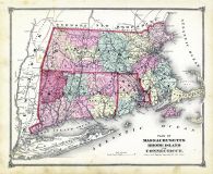 |
State Map - Connecticut Massachusetts Rhode Island
Litchfield County 1874
show address on this map
|
F. W. Beers & Co. |
1874 |
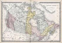 |
British America
Wells County 1881
show address on this map
|
H.H. Hardesty |
1881 |
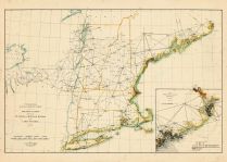 |
St. Croix and Hudson Rivers and Lake Ontario Chart 1882 New England
St. Croix and Hudson River and Lake Ontario Chart 1882 New England
show address on this map
|
U. S. Coastal Survey |
1882 |
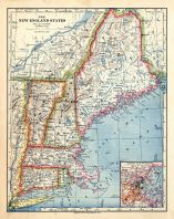 |
New England 1883
New England 1883
show address on this map
|
Van Antwerp Bragg and Co. |
1883 |
 |
United States Map
Winnebago County and Boone County 1886
show address on this map
|
H. R. Page & Co. |
1886 |
 |
New Hampshire and Vermont 1880 State Map
New Hampshire and Vermont State Map 1880 Vermont 1888 Directory
show address on this map
|
Wm. P. Northrup and Co. |
1888 |
 |
Land Survey of the United States
Cass County 1893
show address on this map
|
D.W. Ensign & Co. |
1893 |
 |
The World Map with Principal Cities of the Old World
Fillmore County 1896
show address on this map
|
Geo. A. Ogle & Co. |
1896 |
 |
United States Map
Genesee County 1899
show address on this map
|
Homer A. Day |
1899 |
 |
New Hampshire and Vermont State Map
New Hampshire and Vermont State Map 1899 Vermont 1902 Directory
show address on this map
|
Matthews-Northrup Co. |
1902 |
 |
World Map
Rooks County 1904 to 1905
show address on this map
|
Geo. A. Ogle & Co. |
1904 |
 |
United States Map
Waushara County 1906c
show address on this map
|
C.A. McIntyre and C.H. Terril |
1906c |
 |
World Map
Guthrie County 1917c
show address on this map
|
Kenyon Company |
1917c |
 |
Vermont State Map
Vermont State Map 1910c from Vermont 1928 - 1929 Directory
show address on this map
|
Tuttle Company |
1929 |

 Cart
Cart A variety of printed products can be purchased by clicking on each individual map in the results below.