Address Search
Results for "Latitude 42.638256, Longitude -83.32772"
View these maps overlayed on top of a modern map. You must be a member and logged in to use this feature.
Purchase a series of maps or images documenting the environmental or land use history of this location.

A variety of printed products can be purchased by clicking on each individual map in the results below.
Click on any of the maps below to view a large, zoomable map.
 |
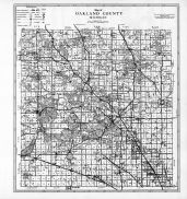
Pontiac - Wards 1, 4, and 5
Oakland County 1896
show address on this map
|
Kace Publishing Company |
1896 |
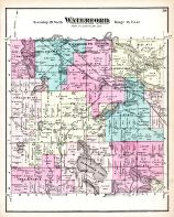 |
Waterford
Oakland County 1872
show address on this map
|
F. W. Beers and Co. |
1872 |
 |
Waterford Township, Drayton Plains, Williams Lake, Huntoon Lake, Cotumabi Bluffs, Clinton River
Oakland County 1896
show address on this map
|
Kace Publishing Company |
1896 |
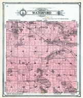 |
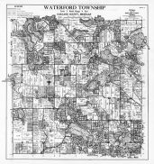
Waterford Township
Oakland County 1908
show address on this map
|
Geo A. Ogle and Co. |
1908 |
 |
Waterford Township
Oakland County 1925
show address on this map
|
W.S. McAlpine Map Company |
1925 |
 |
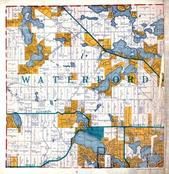
Waterford Township, Drayton Plains, Clintonville, Watkins Lake
Oakland County 1947
show address on this map
|
W. S. McAlpine Map Co. |
1947 |
 |
Oakland County Plan
Oakland County 1872
show address on this map
|
F. W. Beers and Co. |
1872 |
 |
Michigan State Map
Kalamazoo County 1873 Published by F. W. Beers
show address on this map
|
F. W. Beers & Co. |
1873 |
 |
Oakland County Map
Oakland County 1877
show address on this map
|
L. H. Everts and Co. |
1877 |
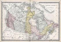 |
British America
Wells County 1881
show address on this map
|
H.H. Hardesty |
1881 |
 |
United States Map
Winnebago County and Boone County 1886
show address on this map
|
H. R. Page & Co. |
1886 |
 |
Land Survey of the United States
Cass County 1893
show address on this map
|
D.W. Ensign & Co. |
1893 |
 |
The World Map with Principal Cities of the Old World
Fillmore County 1896
show address on this map
|
Geo. A. Ogle & Co. |
1896 |
 |
United States Map
Genesee County 1899
show address on this map
|
Homer A. Day |
1899 |
 |
World Map
Rooks County 1904 to 1905
show address on this map
|
Geo. A. Ogle & Co. |
1904 |
 |
United States Map
Waushara County 1906c
show address on this map
|
C.A. McIntyre and C.H. Terril |
1906c |
 |
Outline Map
Oakland County 1908
show address on this map
|
Geo A. Ogle and Co. |
1908 |
 |
Oakland County
Michigan State Atlas 1916 Automobile and Sportsmens Guide
show address on this map
|
B. F. Bowen Co. |
1916 |
 |
World Map
Guthrie County 1917c
show address on this map
|
Kenyon Company |
1917c |
 |
Oakland County, Holly, Groveland, Brandon, Oxford, Addison, Rose, Springfield, Independence, Oakland
Michigan State Atlas 1930c
show address on this map
|
W. W. Hixson & Co. |
1930c |
 |
Oakland County Map
Oakland County 1947
show address on this map
|
W. S. McAlpine Map Co. |
1947 |
 |
Oakland County
Michigan State Atlas 1955
show address on this map
|
Michigan Department of Conservation |
1955 |

 Cart
Cart