
 Cart
CartAddress Search
Results for "Latitude 42.361968, Longitude -71.070175"
View these maps overlayed on top of a modern map. You must be a member and logged in to use this feature.
Purchase a series of maps or images documenting the environmental or land use history of this location.
 A variety of printed products can be purchased by clicking on each individual map in the results below.
Click on any of the maps below to view a large, zoomable map.
 |
Plate M Suffolk County 1874 Vol 1 Boston show address on this map |
G. M. Hopkins & Co. | 1874 |
 |
Plate E Boston 1883 Vol 1 Proper show address on this map |
G. W. Bromley & Co. | 1883 |
 |
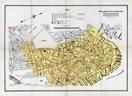
Plate 005 Boston 1888 Vol 1 Proper show address on this map |
G. W. Bromley & Co. | 1888 |
 |
Plate 003 Boston 1902 Proper and Back Bay show address on this map |
G. W. Bromley and Co. | 1902 |
 |
Plate 003 Boston 1908 Proper and Back Bay show address on this map |
G. W. Bromley & Co. | 1908 |
 |
Plate 003 Boston 1912 Proper and Back Bay show address on this map |
G. W. Bromley & Co. | 1912 |
 |
Boston 1914 Business Section Map Boston 1914 Business Section from Boston 1919 Street Directory show address on this map |
Sampson and Murdock Co. | 1914 |
 |
Plate 003 Boston 1917 Proper and Back Bay show address on this map |
G. W. Bromley & Co. | 1917 |
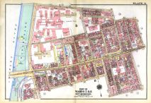 |
Plate 003 Boston 1922 Proper and Back Bay show address on this map |
G. W. Bromley & Co. | 1922 |
 |
Plate 003 Boston 1928 Proper and Back Bay show address on this map |
G. W. Bromley & Co. | 1928 |
 |
Plate 003 Boston 1938 Proper and Back Bay show address on this map |
G. W. Bromely & Co. | 1938 |
 |
Medford 1637 MHS Digital Image 3837 Medford 1637 MHS Digital Image 3837 show address on this map |
Winthrop family | 1637 |
 |
Boston 1676 Created 1920c MHS Digital Image 3850 Boston 1676 Created 1920c MHS Digital Image 3850 show address on this map |
Samuel Chester Clough | 1676 |
 |
Boston 1722 Captain John Bonner Survey reissued and updated in 1835 MHS Digital Image 5024 Boston 1722 Captain John Bonner Survey reissued and updated in 1835 MHS Digital Image 5024 show address on this map |
Capt. John Bonner | 1722 |
 |
Boston 1722 Captain John Bonner Survey third state likely produced in 1725 MHS Digital Image 5023 Boston 1722 Captain John Bonner Survey third state likely produced in 1725 MHS Digital Image 5023 show address on this map |
Capt. John Bonner | 1722 Likely 1725 |
 |
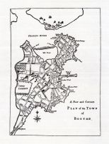
Boston 1764 Bellin Boston 1764 Bellin show address on this map |
Jacques-Nicolas Bellin | 1764 |
 |
Boston 1775 Battle of Bunker Hill 28 November MHS Digital Image 5057 Boston 1775 Battle of Bunker Hill 28 November MHS Digital Image 5057 show address on this map |
S. Biggs | 1775 |
 |
Boston 1776 MHS Digital Image 0096 Boston 1776 MHS Digital Image 0096 show address on this map |
Richard Williams. Engrav?d by Jno. Lodge | 1776 |
 |
Boston Harbor 1777 - APSdigobj3523 Boston Harbor 1777 show address on this map |
Pelham, Henry, 1695?-1754 | 1777 |
 |
Boston 1789 Norman Survey Boston 1789 Norman Survey show address on this map |
Norman | 1789 |
 |
Index Map MHS Digital Image 5052_leaffront Boston 1798 Clough's Finished 60 Page Atlas MHS Digital Series 5052 show address on this map |
Samuel Chester Clough | 1798 |
 |
Boston 1803 Carleton Survey Boston 1803 Carleton Survey show address on this map |
Ofgood Carleton | 1803 |
 |
Somerville and Medford 1807 Somerville and Medford 1807 show address on this map |
Peter Tufts | 1807 |
 |
Boston 1814 MHS Digital Image 5112 Boston 1814 MHS Digital Image 5112 show address on this map |
Benjamin Dearborn | 1814 |
 |
Boston 1825c MHS Digital Image 3516 Boston 1825c MHS Digital Image 3516 show address on this map |
Unattributed | 1825c |
 |
Somerville 1830 Reprinted 1870c Somerville 1830 Reprinted 1870c show address on this map |
Charles D. Elliot | 1830 |
 |
Cambridge 1833 - Version B Cambridge 1833 show address on this map |
Unattributed | 1833 |
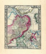 |
Boston 1864 Mitchell Plate Boston 1864 Mitchell Plate show address on this map |
S. Augustus Mitchell | 1864 |
 |
Boston City Middlesex County 1875 show address on this map |
F. W. Beers | 1875 |
 |
Boston 1878 Civil Engineers Sketch - Version B Boston 1878 Civil Engineers Sketch show address on this map |
Office of Improved Sewerage | 1878 |
 |
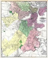
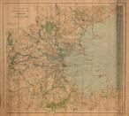
Stoneham, Melrose 5, Medford 8, Malden 2, Everett 6, Somerville 3, Cambridge 1 Middlesex County 1889 show address on this map |
Geo. H. Walker & Co. | 1889 |
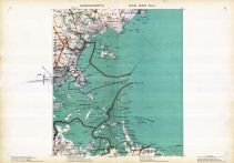 |
Plate 005, Boston, Suffolk, Norfolk, Plymouth, Saugus, Marblehead, Cohasset, Quincy Massachusetts State Atlas 1891 show address on this map |
Geo. H. Walker & Co. | 1891 |
 |
Boston - City Page 006 - Diarrheal Diseases Boston 1895 Vital Statistics from 1884 to 1890 show address on this map |
Department of the Interior | 1895 |
 |
Plate 005 - Quincy, Nahant, Beverly, Chelsea, Hingham, Cohasset Massachusetts State Atlas 1900 show address on this map |
Geo. H. Walker & Co. | 1900 |
 |
Boston 1901 Boston 1901 show address on this map |
Rand McNally | 1901 |
 |
Boston 1902 Public Reservations and Parks Boston 1902 Public Reservations and Parks show address on this map |
Metropolitan Park Commision | 1902 |
 |
Plate 005 - Quincy, Weymouth, Hingham, Cohasset, Nahant, Beverly, Chelsea Massachusetts State Atlas 1904 show address on this map |
Geo. H. Walker & Co. | 1904 |
 |
Cambridge 1905 Regional Map Cambridge 1905 Regional Map show address on this map |
Charles D. Elliot | 1905 |
 |
Boston 1775 Recreated 1907 MHS Digital Image 5005 Boston 1775 Recreated 1907 MHS Digital Image 5005 show address on this map |
Henry Pelham. Engraved in aqua tinta by Francis Jukes | 1907 |
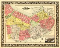 |
Boston 1908 Boston 1908 show address on this map |
Historic Map Works | 1908 |
 |
Plate 005 - Nahant, Revere, Quincy, Weymouth, Hingham Massachusetts State Atlas 1909 show address on this map |
Walker Lithograph & Publishing Co. | 1909 |
 |
Boston 191x Boston 191x show address on this map |
Rand McNally | 191x |
 |
Boston 1922 High Pressure Fire Service Map Boston 1922 High Pressure Fire Service Map show address on this map |
Boston Board of Fire Underwriters | 1922 |
 |
Plate 003 Boston 1924 Zoning Maps show address on this map |
City Planning Board | 1924 |
 |
Massachusetts 1775 MHS Digital Image 0513 Massachusetts 1775 MHS Digital Image 0513 show address on this map |
Bernard Romans | 1775 |
 |
Lake Champlain 1776 MHS Digital Image 2732 Lake Champlain 1776 MHS Digital Image 2732 show address on this map |
William Brasier | 1776 |
 |
Boston Harbor Chart 1790 Des Barres Boston Harbor Chart 1790 Des Barres show address on this map |
Des Barres | 1790 |
 |
Massachusetts 1790c MHS Digital Image 5055 Massachusetts 1790c MHS Digital Image 5055 show address on this map |
Jeremy Belknap | 1790c |
 |
Massachusetts 1802 MHS Digital Image 2113 Massachusetts 1802 MHS Digital Image 2113 show address on this map |
Osgood Carleton | 1802 |
 |
Middlesex County 1830c MHS Digital Image 4297 Middlesex County 1830c MHS Digital Image 4297 show address on this map |
James G. Carter | 1830c |
 |
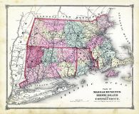
Massachusetts and Rhode Island 1850 MHS Digital Image 5155 Massachusetts and Rhode Island 1850 MHS Digital Image 5155 show address on this map |
Unattributed | 1850 |
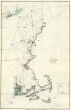 |
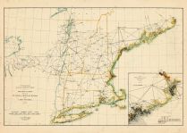
Maine to Rhode Island 1851 Coast Survey Chart Maine to Rhode Island 1851 Coast Survey Chart show address on this map |
A. D. Bache Superintendent | 1851 |
 |
Boston 1852 Boston and Vicinity Wall Map with background Boston 1852 Boston and Vicinity Wall Map show address on this map |
J. B. Shields | 1852 |
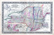 |
New York, New Hampshire, Vermont 1864 Mitchell Plate New York, New Hampshire, Vermont 1864 Mitchell Plate show address on this map |
S. Augustus Mitchell | 1864 |
 |
State Map - Connecticut Massachusetts Rhode Island Litchfield County 1874 show address on this map |
F. W. Beers & Co. | 1874 |
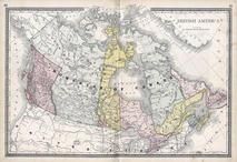 |
British America Wells County 1881 show address on this map |
H.H. Hardesty | 1881 |
 |
St. Croix and Hudson Rivers and Lake Ontario Chart 1882 New England St. Croix and Hudson River and Lake Ontario Chart 1882 New England show address on this map |
U. S. Coastal Survey | 1882 |
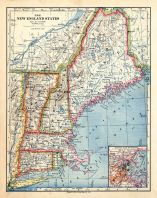 |
New England 1883 New England 1883 show address on this map |
Van Antwerp Bragg and Co. | 1883 |
 |
United States Map Winnebago County and Boone County 1886 show address on this map |
H. R. Page & Co. | 1886 |
 |
Land Survey of the United States Cass County 1893 show address on this map |
D.W. Ensign & Co. | 1893 |
 |
The World Map with Principal Cities of the Old World Fillmore County 1896 show address on this map |
Geo. A. Ogle & Co. | 1896 |
 |
United States Map Genesee County 1899 show address on this map |
Homer A. Day | 1899 |
 |
World Map Rooks County 1904 to 1905 show address on this map |
Geo. A. Ogle & Co. | 1904 |
 |
United States Map Waushara County 1906c show address on this map |
C.A. McIntyre and C.H. Terril | 1906c |
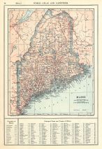 |
Maine State Map 1908 Revised 1914 Maine State Map 1908 Revised 1914 show address on this map |
L. L. Poates | 1914 |
 |
World Map Guthrie County 1917c show address on this map |
Kenyon Company | 1917c |