Click on any of the maps below to view a large, zoomable map.
 |
Township 84 North, Range 18 West, Albtion, Marietta, Marshalltown
Marshall County 1871
show address on this map
|
Harrison & Warner |
1871 |
 |
Linn and Marshall Township
Marshall County 1907
show address on this map
|
Iowa Publishing Co. |
1907 |
 |
Marshall County
Marshall County 1920c
show address on this map
|
Anderson Publishing Company |
1920 |
 |
Iowa, Taylor, Marietta, Marshall
Marshall County 1967
show address on this map
|
Title Atlas Company |
1967 |
 |
Code 7 - Iowa Township - SE, Taylor Township - S, Marietta Township - E, Marshall Township - N, Albion
Marshall County 1981
show address on this map
|
Title Atlas Company |
1981 |
 |
Linn and Marshall, Iowa, Taylor, Marietta T84N-R18W
Marshall County 2001 - 2002
show address on this map
|
R. C. Booth Enterprises |
2001 |
 |
Linn and Marshall, Iowa, Taylor, Marietta T84N-R18W
Marshall County 2003 - 2004
show address on this map
|
R. C. Booth Enterprises |
2003 |
 |
Linn and Marshall, Iowa, Taylor, Marietta T84N-R18W
Marshall County 2007 - 2008
show address on this map
|
R. C. Booth Enterprises |
2007 |
 |
Mississippi River 1807 - APSdigobj3545
Mississippi River 1807
show address on this map
|
Nav, Anthony; Pike, Zebulon Montgomery, 1779-1813; Thompson; Lewis, M. |
1807 |
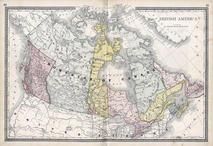 |
British America
Wells County 1881
show address on this map
|
H.H. Hardesty |
1881 |
 |
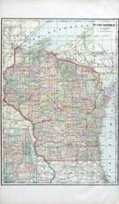
United States Map
Winnebago County and Boone County 1886
show address on this map
|
H. R. Page & Co. |
1886 |
 |
Iowa Rail Road Sectional Map
Keokuk County 1887
show address on this map
|
C. M. Foote & Co. |
1887 |
 |
Iowa State Map
Hardin County 1892
show address on this map
|
North West Publishing Co. |
1892 |
 |
Land Survey of the United States
Cass County 1893
show address on this map
|
D.W. Ensign & Co. |
1893 |
 |
The World Map with Principal Cities of the Old World
Fillmore County 1896
show address on this map
|
Geo. A. Ogle & Co. |
1896 |
 |
United States Map
Genesee County 1899
show address on this map
|
Homer A. Day |
1899 |
 |
World Map
Rooks County 1904 to 1905
show address on this map
|
Geo. A. Ogle & Co. |
1904 |
 |
United States Map
Waushara County 1906c
show address on this map
|
C.A. McIntyre and C.H. Terril |
1906c |
 |
Wisconsin State Map
Pierce County 1908
show address on this map
|
Geo. A. Ogle & Co. |
1908 |
 |
Wisconsin State Map
Rock County 1917
show address on this map
|
Hennessey & Co. |
1917 |
 |
World Map
Guthrie County 1917c
show address on this map
|
Kenyon Company |
1917c |
 |
Minnesota State Map
Yellow Medicine County 1929
show address on this map
|
Webb Publishing Co. |
1929 |
 |
Marshall County Map
Iowa State Atlas 1930c
show address on this map
|
W.W. Hixson & Co. |
1930 |
 |
Minnesota State Map
Big Stone County 1931
show address on this map
|
Webb Publishing Co. |
1931 |
 |
Iowa State Map
Lyon County 1962
show address on this map
|
Thomas O. Nelson Co. |
1962 |

 Cart
Cart A variety of printed products can be purchased by clicking on each individual map in the results below.