
 Cart
CartAddress Search
Results for "Latitude 41.256977, Longitude -95.851257"
View these maps overlayed on top of a modern map. You must be a member and logged in to use this feature.
Purchase a series of maps or images documenting the environmental or land use history of this location.
 A variety of printed products can be purchased by clicking on each individual map in the results below.
Click on any of the maps below to view a large, zoomable map.
 |
Pottawattamie County Iowa 1875 State Atlas show address on this map |
A. T. Andreas | 1875 |
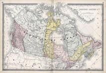 |
British America Wells County 1881 show address on this map |
H.H. Hardesty | 1881 |
 |
Pottawattamie County Pottawattamie County 1885 show address on this map |
C. R. Allen and Co. | 1885 |
 |
United States Map Winnebago County and Boone County 1886 show address on this map |
H. R. Page & Co. | 1886 |
 |
Iowa Rail Road Sectional Map Keokuk County 1887 show address on this map |
C. M. Foote & Co. | 1887 |
 |
Iowa State Map Hardin County 1892 show address on this map |
North West Publishing Co. | 1892 |
 |
Land Survey of the United States Cass County 1893 show address on this map |
D.W. Ensign & Co. | 1893 |
 |
The World Map with Principal Cities of the Old World Fillmore County 1896 show address on this map |
Geo. A. Ogle & Co. | 1896 |
 |
United States Map Genesee County 1899 show address on this map |
Homer A. Day | 1899 |
 |
County Outline Map Pottawattamie County 1902 show address on this map |
Geo. A. Ogle | 1902 |
 |
World Map Rooks County 1904 to 1905 show address on this map |
Geo. A. Ogle & Co. | 1904 |
 |
United States Map Waushara County 1906c show address on this map |
C.A. McIntyre and C.H. Terril | 1906c |
 |
Iowa State Map Buena Vista County 1908 show address on this map |
Geo. A. Ogle & Co. | 1908 |
 |
Pottawattamie County Mills and Pottawattamie Counties 1913 show address on this map |
Bee Publishing | 1913 |
 |
World Map Guthrie County 1917c show address on this map |
Kenyon Company | 1917c |
 |
Topographical Map Pottawattamie County 1919 show address on this map |
Anderson Publishing Company | 1919 |
 |
Minnesota State Map Yellow Medicine County 1929 show address on this map |
Webb Publishing Co. | 1929 |
 |
Pottawattamie County Map Iowa State Atlas 1930c show address on this map |
W.W. Hixson & Co. | 1930 |
 |
Index, Index Map Pottawattamie County 1935 show address on this map |
The Neola Gazette Reporter | 1935 |
 |
Missouri State Map Missouri State Atlas 1940c show address on this map |
W. W. Hixson & Company | 1940c |
 |
Iowa State Map Lyon County 1962 show address on this map |
Thomas O. Nelson Co. | 1962 |
 |
Nebraska County Map Cass County 1963 Published by Standard Atlas Co show address on this map |
Standard Atlas Co. | 1963 |
 |
Pottawattamie County 1982 Shelby County 1989 show address on this map |
Title Atlas Company | 1989 |