
 Cart
CartAddress Search
Results for "Latitude 39.525512, Longitude -77.742692"
View these maps overlayed on top of a modern map. You must be a member and logged in to use this feature.
Purchase a series of maps or images documenting the environmental or land use history of this location.
 A variety of printed products can be purchased by clicking on each individual map in the results below.
Click on any of the maps below to view a large, zoomable map.
 |
Washington County 1859 Wall Map 44x51 Washington County 1859 Wall Map show address on this map |
Taggart Thomas | 1859 |
 |
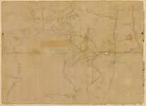
Jefferson County 1862 Wall Map 24x35 Jefferson County 1862 Wall Map show address on this map |
Brown S. Howell | 1862 |
 |
Williamsport 1, Downsville Washington County 1877 show address on this map |
Lake, Griffing & Stevenson | 1877 |
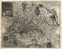 |
Virginia and Jamestown 1606 Described by Captain John Smith Engraved by William Hole Virginia and Jamestown 1606 Described by Captain John Smith Engraved by William Hole show address on this map |
William Hole | 1606 |
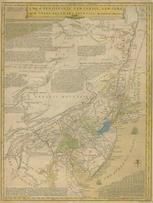 |
Pennsylvania, New Jersey, New York, Delaware 1749 - APSdigobj3524 Pennsylvania, New Jersey, New York, Delaware 1749 show address on this map |
Evans, Lewis, 1700?-1756 | 1749 |
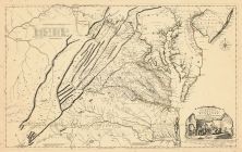 |
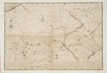
Virginia 1755 Map of the Most Inhabited part of Virginia etc Virginia 1755 Map of the Most Inhabited part of Virginia etc Created by Fry and Jefferson in 1751 show address on this map |
Joshua Fry and Peter Jefferson | 1755 |
 |
Pennsylvania 1770 - APSdigobj3576 Pennsylvania 1770 show address on this map |
Scull, William | 1770 |
 |
Pennsylvania 1791 - APSdigobj3558 Pennsylvania 1791 show address on this map |
Howell, Reading, 1743-1827 | 1791 |
 |
Pennsylvania 1791c - APSdigobj3529 Pennsylvania 1791c show address on this map |
Adlum, John, 1759-1836; Wallis, John | 1791c |
 |
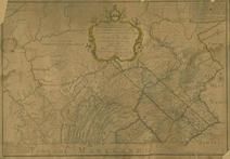
Pennsylvania 1807 including neighboring states - APSdigobj3463 Pennsylvania 1807 including neighboring states show address on this map |
Pursh, Frederick, 1774-1820 | 1807 |
 |
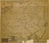
State Map Virginia 1850 State Map show address on this map |
Thomas Cowperthwait | 1850 |
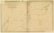 |
Lake Ontario - Lake Erie - Lake Champlain 1861 Lighthouse Charts - APSdigobj3543_001 Lake Ontario - Lake Erie - Lake Champlain 1861 Lighthouse Charts show address on this map |
Meade, George Gordon, 1815-1872 | 1861 |
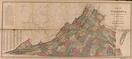 |
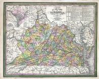
Virginia State Map 1871 Virginia State Map 1871 show address on this map |
N.V. Randolph | 1871 |
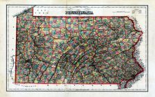 |
Pennsylvania State Adams County 1872 show address on this map |
I. W. Field & Company | 1872 |
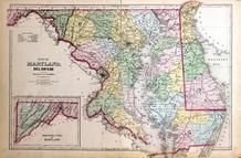 |
Maryland, Deleware and District of Columbia Map Washington D.C. and Montgomery County, MD 1879 show address on this map |
G.M. Hopkins | 1879 |
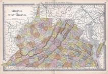 |
Virginia, West Virginia Wells County 1881 show address on this map |
H.H. Hardesty | 1881 |
 |
United States Map Winnebago County and Boone County 1886 show address on this map |
H. R. Page & Co. | 1886 |
 |
Land Survey of the United States Cass County 1893 show address on this map |
D.W. Ensign & Co. | 1893 |
 |
The World Map with Principal Cities of the Old World Fillmore County 1896 show address on this map |
Geo. A. Ogle & Co. | 1896 |
 |
United States Map Genesee County 1899 show address on this map |
Homer A. Day | 1899 |
 |
World Map Rooks County 1904 to 1905 show address on this map |
Geo. A. Ogle & Co. | 1904 |
 |
United States Map Waushara County 1906c show address on this map |
C.A. McIntyre and C.H. Terril | 1906c |
 |
World Map Guthrie County 1917c show address on this map |
Kenyon Company | 1917c |