
 Cart
CartAddress Search
Results for "Latitude 37.565376, Longitude -122.32806"
View these maps overlayed on top of a modern map. You must be a member and logged in to use this feature.
Purchase a series of maps or images documenting the environmental or land use history of this location.
 A variety of printed products can be purchased by clicking on each individual map in the results below.
Click on any of the maps below to view a large, zoomable map.
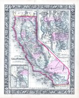 |
California, Utah, San Francisco Bay 1864 Mitchell Plate California, Utah, San Francisco Bay 1864 Mitchell Plate show address on this map |
S. Augustus Mitchell | 1864 |
 |
British America Wells County 1881 show address on this map |
H.H. Hardesty | 1881 |
 |
United States Map Winnebago County and Boone County 1886 show address on this map |
H. R. Page & Co. | 1886 |
 |
Land Survey of the United States Cass County 1893 show address on this map |
D.W. Ensign & Co. | 1893 |
 |
The World Map with Principal Cities of the Old World Fillmore County 1896 show address on this map |
Geo. A. Ogle & Co. | 1896 |
 |
United States Map Genesee County 1899 show address on this map |
Homer A. Day | 1899 |
 |
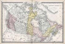
General Map of Adjacent Parts of North America And Asia Alaska Boundary Tribunal Atlas 1903 Maps from 1795 to 1903 show address on this map |
Govt. Publication | 1903 |
 |
World Map Rooks County 1904 to 1905 show address on this map |
Geo. A. Ogle & Co. | 1904 |
 |
United States Map Waushara County 1906c show address on this map |
C.A. McIntyre and C.H. Terril | 1906c |
 |
World Map Guthrie County 1917c show address on this map |
Kenyon Company | 1917c |
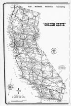 |
California State Road Map Los Angeles County 1961 show address on this map |
Renie Map Service | 1961 |
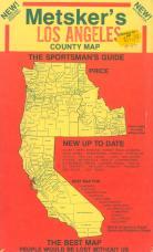 |
Envelope Front - Title Los Angeles County 1975c show address on this map |
Metsker Maps | 1975 |
 |
San Francisco Bay District 1980 to 1996 Eight Counties Tracing San Francisco Bay District 1980 to 1996 Eight Counties show address on this map |
Metsker Maps | 1980 |