
 Cart
CartAddress Search
Results for "Latitude 36.390747, Longitude -97.8926369"
View these maps overlayed on top of a modern map. You must be a member and logged in to use this feature.
Purchase a series of maps or images documenting the environmental or land use history of this location.
 A variety of printed products can be purchased by clicking on each individual map in the results below.
Click on any of the maps below to view a large, zoomable map.
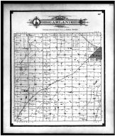 |
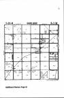
Garland Township, Enid Garfield County 1906 show address on this map |
Geo A. Ogle & Co. | 1906 |
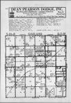 |
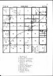
Garland T22N-R7W Garfield County 1968 show address on this map |
Directory Service Company | 1968 |
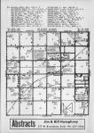 |
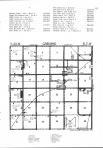
Garland T22N-R7W Garfield County 1970 show address on this map |
Directory Service Company | 1970 |
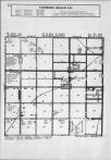 |
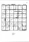
Garland T22N-R7W Garfield County 1974 show address on this map |
Directory Service Company | 1974 |
 |
Garland T22N-R7W Garfield County 1975 show address on this map |
Directory Service Company | 1975 |
 |
Garland T22N-R7W Garfield County 1976 show address on this map |
Directory Service Company | 1976 |
 |
Garland T22N-R7W Garfield County 1980 show address on this map |
Directory Service Company | 1980 |
 |
Garland T22N-R7W Garfield County 1983 show address on this map |
Directory Service Company | 1983 |
 |
Texas, Indian Territory Wells County 1881 show address on this map |
H.H. Hardesty | 1881 |
 |
United States Map Winnebago County and Boone County 1886 show address on this map |
H. R. Page & Co. | 1886 |
 |
Land Survey of the United States Cass County 1893 show address on this map |
D.W. Ensign & Co. | 1893 |
 |
The World Map with Principal Cities of the Old World Fillmore County 1896 show address on this map |
Geo. A. Ogle & Co. | 1896 |
 |
United States Map Genesee County 1899 show address on this map |
Homer A. Day | 1899 |
 |
World Map Rooks County 1904 to 1905 show address on this map |
Geo. A. Ogle & Co. | 1904 |
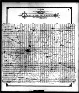 |
Garfield County Outline Map Garfield County 1906 show address on this map |
Geo A. Ogle & Co. | 1906 |
 |
United States Map Waushara County 1906c show address on this map |
C.A. McIntyre and C.H. Terril | 1906c |
 |
World Map Guthrie County 1917c show address on this map |
Kenyon Company | 1917c |
 |
Index Map Kansas State Atlas 1958 County Highway Maps show address on this map |
Topographic Land Surveyors | 1958 |