
 Cart
CartAddress Search
Results for "Latitude 33.9393161, Longitude -118.2717956"
View these maps overlayed on top of a modern map. You must be a member and logged in to use this feature.
Purchase a series of maps or images documenting the environmental or land use history of this location.
 A variety of printed products can be purchased by clicking on each individual map in the results below.
Click on any of the maps below to view a large, zoomable map.
 |
show address on this map |
||
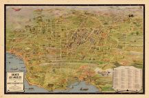 |
Los Angeles 1932 Tourist Map Los Angeles 1932 Tourist Map show address on this map |
Leuschner, K. M. | 1932 |
 |
Page 069 Los Angeles 1943 Pocket Atlas show address on this map |
Renie Atlas Publications | 1943 |
 |
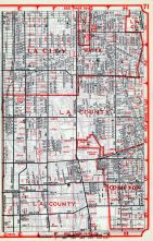
Los Angeles County - Page 071 Los Angeles and Los Angeles County 1949 show address on this map |
Renie Atlas | 1949 |
 |
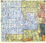
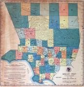
Plate 026 Los Angeles County 1950c show address on this map |
Rapid Blue Print Co. | 1950c |
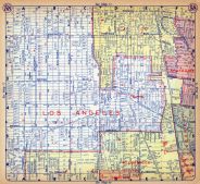 |
Plate 058 Los Angeles County 1956 show address on this map |
Thomas Bros. | 1956 |
 |
Page 058 Los Angeles County 1957 Street Atlas show address on this map |
Thomas Bros. | 1957 |
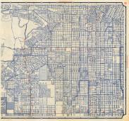 |
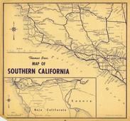
Plate 021 Los Angeles 195x show address on this map |
Union Oil Company by Rand McNally and Co. | 195x |
 |
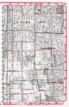
Los Angeles County - Page 071 Los Angeles County 1961 show address on this map |
Renie Map Service | 1961 |
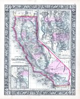 |
California, Utah, San Francisco Bay 1864 Mitchell Plate California, Utah, San Francisco Bay 1864 Mitchell Plate show address on this map |
S. Augustus Mitchell | 1864 |
 |
California, Nevada Wells County 1881 show address on this map |
H.H. Hardesty | 1881 |
 |
United States Map Winnebago County and Boone County 1886 show address on this map |
H. R. Page & Co. | 1886 |
 |
Land Survey of the United States Cass County 1893 show address on this map |
D.W. Ensign & Co. | 1893 |
 |
The World Map with Principal Cities of the Old World Fillmore County 1896 show address on this map |
Geo. A. Ogle & Co. | 1896 |
 |
United States Map Genesee County 1899 show address on this map |
Homer A. Day | 1899 |
 |
World Map Rooks County 1904 to 1905 show address on this map |
Geo. A. Ogle & Co. | 1904 |
 |
United States Map Waushara County 1906c show address on this map |
C.A. McIntyre and C.H. Terril | 1906c |
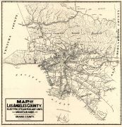 |
Los Angeles and Orange Counties 1912 Railway Map Los Angeles and Orange Counties 1912 Railway Map show address on this map |
Newman, T. | 1912 |
 |
Los Angeles and the San Gabriel Mountains 1915 Los Angeles and the San Gabriel Mountains 1915 show address on this map |
Automobile Club of Southern California | 1915 |
 |
World Map Guthrie County 1917c show address on this map |
Kenyon Company | 1917c |
 |
Index Map Los Angeles County 1950c show address on this map |
Rapid Blue Print Co. | 1950c |
 |
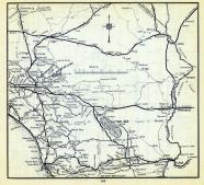
California Highway Map 1 San Diego County 1956 show address on this map |
Thomas Bros. | 1956 |
 |
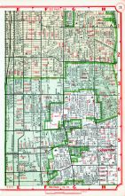
Page115 Los Angeles County 1957 Street Atlas show address on this map |
Thomas Bros. | 1957 |
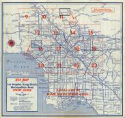 |
Key Map Los Angeles 195x show address on this map |
Union Oil Company by Rand McNally and Co. | 195x |
 |
California State Road Map Los Angeles County 1961 show address on this map |
Renie Map Service | 1961 |
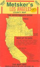 |
Envelope Front - Title Los Angeles County 1975c show address on this map |
Metsker Maps | 1975 |