
 Cart
CartAddress Search
Results for "Latitude 29.6534342, Longitude -82.3250325"
View these maps overlayed on top of a modern map. You must be a member and logged in to use this feature.
Purchase a series of maps or images documenting the environmental or land use history of this location.
 A variety of printed products can be purchased by clicking on each individual map in the results below.
Click on any of the maps below to view a large, zoomable map.
 |
Sheet 004 Gainesville 1887 show address on this map |
Sanborn Map Company | 1887 |
 |
Sheet 004 Gainesville 1892 show address on this map |
Sanborn Map Company | 1892 |
 |
Sheet 003 Gainesville 1897 show address on this map |
Sanborn Map Company | 1897 |
 |
Sheet 006 Gainesville 1903 show address on this map |
Sanborn Map Company | 1903 |
 |
Sheet 008 Gainesville 1909 show address on this map |
Sanborn Map Company | 1909 |
 |
Sheet 011 Gainesville 1913 show address on this map |
Sanborn Map Company | 1913 |
 |
Sheet 002 Gainesville 1922 show address on this map |
Sanborn Map Company | 1922 |
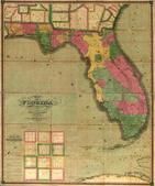 |
Florida 1829 State Map Florida 1829 State Map show address on this map |
Searcy, I.G. | 1829 |
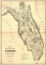 |
Florida 1839 State Map Florida 1839 State Map show address on this map |
United States Army Corps of Engineers | 1839 |
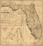 |
Florida 1846 State Map Florida 1846 State Map show address on this map |
Bruff, Joseph Goldsborough | 1846 |
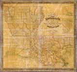 |
Louisiana 1853 State Map with Landowner Names 43x46 Louisiana 1853 State Map with Landowner Names show address on this map |
La Tourrette, John | 1853 |
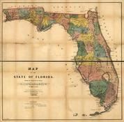 |
Florida 1856 State Map Florida 1856 State Map show address on this map |
Drew, Columbus | 1856 |
 |
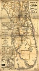
Florida 1874 State Map Florida 1874 State Map show address on this map |
Drew, Columbus | 1874 |
 |
West Indies Wells County 1881 show address on this map |
H.H. Hardesty | 1881 |
 |
United States Map Winnebago County and Boone County 1886 show address on this map |
H. R. Page & Co. | 1886 |
 |
Florida 1891 State Map Florida 1891 State Map show address on this map |
Matthews-Northup Company | 1891 |
 |
Land Survey of the United States Cass County 1893 show address on this map |
D.W. Ensign & Co. | 1893 |
 |
The World Map with Principal Cities of the Old World Fillmore County 1896 show address on this map |
Geo. A. Ogle & Co. | 1896 |
 |
United States Map Genesee County 1899 show address on this map |
Homer A. Day | 1899 |
 |
World Map Rooks County 1904 to 1905 show address on this map |
Geo. A. Ogle & Co. | 1904 |
 |
United States Map Waushara County 1906c show address on this map |
C.A. McIntyre and C.H. Terril | 1906c |
 |
World Map Guthrie County 1917c show address on this map |
Kenyon Company | 1917c |