
 Cart
Cart
|
ITEM #US1608994
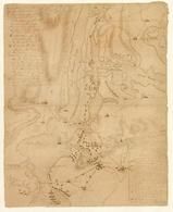
New York City 1776c Showing British and American Troop Positions - APSdigobj3471From New York City 1776c Showing British and American Troop Positions, New York Published by Peale, Charles Willson, 1741-1827 in 1776c |
 Buy this Map »
Full Title: [New York, showing British and American troop positions].; Creator: Peale, Charles Willson, 1741-1827; Date: ca. 1776; Publisher: Unattributed; Contributor: Unattributed; Description: Manuscript map showing the troop positions of British and American forces during the Revolutionary War.; Notes: Unattributed; Language: English; APS Digital ID: APSdigobj3471


Map Information
Full Title: New York City 1776c Showing British and American Troop Positions - APSdigobj3471
Full Atlas Title: New York City 1776c Showing British and American Troop Positions
State: New York
Location 1: North America
Location 2: United States, New York
Publish Date: 1776c
Publisher: Peale, Charles Willson, 1741-1827
Number Maps in the Atlas: 1
Map Original Width: 13.86"
Map Original Height: 17.04"
Item Number: US1608994
Collection: Historic Map Works Rare Historic Maps Collection
Image Quality: High quality scan of original that is perfect for printed fine-art quality reproduction.
Source Institution:

© American Philosophical Society, Philadelphia, PA, USA
Souce Media:
Original Document
© American Philosophical Society, Philadelphia, PA, USA
Souce Media:
Original Document
| This antique map (New York City 1776c Showing British...) and atlas (New York City 1776c Showing British and American Troop Positions) are part of the Historic Map Works, Residential Genealogy™ historical map collection, the largest digital collection of rare, ancient, old, historical, cadastral and antiquarian maps of its type. We currently have over 1,662,956 images available online. You can read about the collection or browse the entire collection. |