
 Cart
Cart
|
ITEM #HB992074
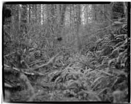
Photo Point #6 - 254 Yards East Of Dolph Townsite, Looking EastFrom Dolph Toll Road, State Highway 22, Sinslaw National Forest, Hebo, Tillamook County, OR, Oregon Published by Library of Congress in 1968 |
 Buy »
Buy »Are you a genealogist researching your ancestors in Oregon?
This map of Photo Point #6 - 254 Yards East Of Dolph Townsite, Looking East from Dolph Toll Road, State Highway 22, Sinslaw National Forest, Hebo, Tillamook County, OR contains the following family names (or surnames):
Baker, Cedar, Franklin, John, King, Mass, Monroe, Ridge, Ro
Map Information
Full Title: Photo Point #6 - 254 Yards East Of Dolph Townsite, Looking East
Full Atlas Title: Dolph Toll Road, State Highway 22, Sinslaw National Forest, Hebo, Tillamook County, OR
State: Oregon
Location 1:
Location 2:
Publish Date: 1968
Publisher: Library of Congress
Number Maps in the Atlas: 57
Map Original Width: 7"
Map Original Height: 5"
Item Number: HB992074
Collection: Historic Map Works Rare Historic Maps Collection
Image Quality: Informational quality scan which is suitable for research use and lends itself nicely to being reproduced in our research print format.
Source Institution:

Souce Media:
Original Document
Souce Media:
Original Document
| This antique map (Photo Point #6 - 254 Yards East Of ...) and atlas (Dolph Toll Road, State Highway 22, Sinslaw National Forest, Hebo, Tillamook County, OR) are part of the Historic Map Works, Residential Genealogy™ historical map collection, the largest digital collection of rare, ancient, old, historical, cadastral and antiquarian maps of its type. We currently have over 1,662,956 images available online. You can read about the collection or browse the entire collection. |