
 Cart
Cart
|
ITEM #HB634040
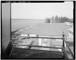
Light Tower, View Northeast From Light Platform, Southwest Side Of Boat House And Keeper's House, With Detail Of Railing In ForegroundFrom Grindle Point Light Station, Western end of Ferry Road on Grindle Point, Islesboro, Waldo County, ME, Maine Published by Library of Congress in 1933 |
 Buy »
Buy »Are you a genealogist researching your ancestors in Maine?
This map of Light Tower, View Northeast From Light Platform, Southwest Side Of Boat House And Keeper's House, With Detail Of Railing In Foreground from Grindle Point Light Station, Western end of Ferry Road on Grindle Point, Islesboro, Waldo County, ME contains the following family names (or surnames):
Doom, Jui, Kinds, Ohs, J
Map Information
Full Title: Light Tower, View Northeast From Light Platform, Southwest Side Of Boat House And Keeper's House, With Detail Of Railing In Foreground
Full Atlas Title: Grindle Point Light Station, Western end of Ferry Road on Grindle Point, Islesboro, Waldo County, ME
State: Maine
Location 1:
Location 2:
Publish Date: 1933
Publisher: Library of Congress
Number Maps in the Atlas: 23
Map Original Width: 7"
Map Original Height: 5"
Item Number: HB634040
Collection: Historic Map Works Rare Historic Maps Collection
Image Quality: Informational quality scan which is suitable for research use and lends itself nicely to being reproduced in our research print format.
Source Institution:

Souce Media:
Original Document
Souce Media:
Original Document
| This antique map (Light Tower, View Northeast From Li...) and atlas (Grindle Point Light Station, Western end of Ferry Road on Grindle Point, Islesboro, Waldo County, ME) are part of the Historic Map Works, Residential Genealogy™ historical map collection, the largest digital collection of rare, ancient, old, historical, cadastral and antiquarian maps of its type. We currently have over 1,662,956 images available online. You can read about the collection or browse the entire collection. |