
 Cart
Cart
|
ITEM #HB1235142
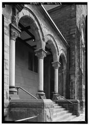
BWPhotos 170642From St. Paul's Episcopal Church & Parish House, 904 East Knapp Street, Milwaukee, Milwaukee County, WI, Wisconsin Published by Library of Congress in 1933 |
 Buy »
Buy »
Map Information
Full Title: BWPhotos 170642
Full Atlas Title: St. Paul's Episcopal Church & Parish House, 904 East Knapp Street, Milwaukee, Milwaukee County, WI
State: Wisconsin
Location 1:
Location 2:
Publish Date: 1933
Publisher: Library of Congress
Number Maps in the Atlas: 63
Map Original Width: 5"
Map Original Height: 7"
Item Number: HB1235142
Collection: Historic Map Works Rare Historic Maps Collection
Image Quality: Informational quality scan which is suitable for research use and lends itself nicely to being reproduced in our research print format.
Source Institution:

Souce Media:
Original Document
Souce Media:
Original Document
| This antique map (BWPhotos 170642) and atlas (St. Paul's Episcopal Church & Parish House, 904 East Knapp Street, Milwaukee, Milwaukee County, WI) are part of the Historic Map Works, Residential Genealogy™ historical map collection, the largest digital collection of rare, ancient, old, historical, cadastral and antiquarian maps of its type. We currently have over 1,662,956 images available online. You can read about the collection or browse the entire collection. |