
 Cart
Cart
|
ITEM #HB122578
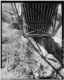
East Abutment, L11 Truss BracingFrom Honeydew Creek Bridge, Wilder Ridge Road, Honeydew, Humboldt County, CA, California Published by Library of Congress in 1968 |
 Buy »
Buy »
Map Information
Full Title: East Abutment, L11 Truss Bracing
Full Atlas Title: Honeydew Creek Bridge, Wilder Ridge Road, Honeydew, Humboldt County, CA
State: California
Location 1:
Location 2:
Publish Date: 1968
Publisher: Library of Congress
Number Maps in the Atlas: 43
Map Original Width: 5"
Map Original Height: 7"
Item Number: HB122578
Collection: Historic Map Works Rare Historic Maps Collection
Image Quality: Informational quality scan which is suitable for research use and lends itself nicely to being reproduced in our research print format.
Source Institution:

Souce Media:
Original Document
Souce Media:
Original Document
| This antique map (East Abutment, L11 Truss Bracing) and atlas (Honeydew Creek Bridge, Wilder Ridge Road, Honeydew, Humboldt County, CA) are part of the Historic Map Works, Residential Genealogy™ historical map collection, the largest digital collection of rare, ancient, old, historical, cadastral and antiquarian maps of its type. We currently have over 1,662,956 images available online. You can read about the collection or browse the entire collection. |