
 Cart
Cart
|
ITEM #HB1075656
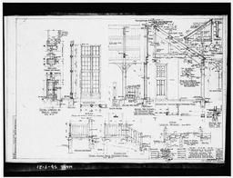
Exterior DetailsFrom Wind Cave National Park, Administration & Operator's Building, Approximately 2.5 miles southeast of U.S. Route 38, Custer, Custer County, SD, South Dakota Published by Library of Congress in 1933 |
 Buy »
Buy »Are you a genealogist researching your ancestors in South Dakota?
This map of Exterior Details from Wind Cave National Park, Administration & Operator's Building, Approximately 2.5 miles southeast of U.S. Route 38, Custer, Custer County, SD contains the following family names (or surnames):
Adolph, Agnes, Albert, Ann, Aubrey, Austin, Beatrice, Belle, Bernard, Betty, Beulah, Beverly, Blake, Brian, Calvin, Carl, Carol, Carvell, Cecil, Chad, Charles, Chester, Clarence, Clyde, Cynthia, Dale, Daniel, Danny, Darrell, David, Dennis, Don, Donald, Donna, Donnie, Doris, Dwane, Dwight, Earl, Edgar, Edith, Elizabeth, Elmer, Elza, Ernest, Ester, Everett, Fay, Ferris, Florence, Forrest, Gary, Gentry, George, Gerald, Gerhold, Getz, Giberson, Gibson, Giesler, Giles, Gillett, Gilpin, Glasscock, Glen, Glick, Goddard, Goldie, Gorden, Gordon, Graham, Grauer, Graven, Green, Gregory, Greuel, Griffin, Grubb, Grunert, Guin, Gurley, Guthrie, Hackenberg, Hadley, Hagan, Halbrook, Hale, Hall, Hamilton, Haney, Hankins, Hanna, Hannon, Harbert, Harden, Hardesty, Hardimon, Harding, Hardy, Harlan, Harley, Harmon, Harms, Harold, Harrington, Harris, Harrison, Hart, Hartke, Hartley, Hartman, Harwell, Hash, Hatch, Hatfield, Haveman, Hawkins, Hayes, Hays, Hayward, Hazel, Hazen, Hazlett, Hedges, Heiden, Heil, Helen, Helton, Henderson, Hendricks, Henneberry, Hennigh, Henning, Hennings, Henry, Herbert, Herron, Hess, Hessler, Hicks, Higgins, High, Highland, Highsmith, Hight, Hiler, Hille, Himes, Hinshaw, Hinton, Hoagland, Hobby, Hodson, Hoene, Hoffman, Holthaus, Hooper, Hooten, Hopewell, Hopper, Horseman, Horsman, Hostetler, Howard, Howe, Howell, Howse, Hubbard, Hubbartt, Hubner, Jack, Jacob, James, Janis, Jerry, Jim, Joe, John, Joseph, Judy, June, Karen, Keith, Ken, Kenneth, Lands, Larry, Lawrence, Leland, Leon, Leonard, Lester, Lewis, Linda, Lola, Louis, Louise, Lucy, Lyle, Lynn, Margaret, Marian, Marion, Mark, Marsha, Martha, Mary, Mason, Melvin, Merrill, Michael, Mike, Mildred, Mow, Myrtle, Nancy, Naomi, Nina, Norma, Norman, Norton, Omer, Owen, Paul, Pauline, Pen, Phillip, Rena, Rex, Rich, Richard, Robert, Roberta, Roger, Rolland, Ronald, Roscoe, Rosella, Roy, Ruth, Sarah, Seth, Shelby, Shirley, Terry, Thomas, Tim, Timothy, Tom, Tony, Trace, Verne, Victor, Victorine, Vida, Virgil, Virginia, Walter, Wanda, Warren, Wayne, William, Zo
Map Information
Full Title: Exterior Details
Full Atlas Title: Wind Cave National Park, Administration & Operator's Building, Approximately 2.5 miles southeast of U.S. Route 38, Custer, Custer County, SD
State: South Dakota
Location 1:
Location 2:
Publish Date: 1933
Publisher: Library of Congress
Number Maps in the Atlas: 55
Map Original Width: 7"
Map Original Height: 5"
Item Number: HB1075656
Collection: Historic Map Works Rare Historic Maps Collection
Image Quality: Informational quality scan which is suitable for research use and lends itself nicely to being reproduced in our research print format.
Source Institution:

Souce Media:
Original Document
Souce Media:
Original Document
| This antique map (Exterior Details) and atlas (Wind Cave National Park, Administration & Operator's Building, Approximately 2.5 miles southeast of U.S. Route 38, Custer, Custer County, SD) are part of the Historic Map Works, Residential Genealogy™ historical map collection, the largest digital collection of rare, ancient, old, historical, cadastral and antiquarian maps of its type. We currently have over 1,662,956 images available online. You can read about the collection or browse the entire collection. |