 |
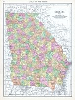
Georgia |
World Atlas 1913 |
 |
Rand McNally and Com... |
1913 |
HMW |
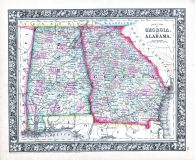 |
Georgia and Alabama |
World Atlas 1864 Mitchells New... |
|
S. Augustus Mitchell |
1864 |
HMW |
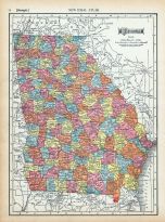 |
Page 074 - Georgia |
World Atlas 1911c from Minneso... |
|
Rand, McNally and Co... |
1911 |
HMW |
 |
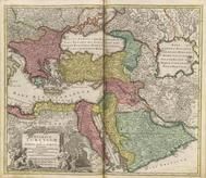
ASIAE III TAB: 0215-00 |
GEOGRAPHIAE LIBRI OCTO RECOGNI... |
|
PTOLEMY, C. / MERCAT... |
1584 |
OML |
|
 |
CIRCULI FRANCONIAE PARS ORIENT... |
Grosser Atlas |
|
Homann, Johann Bapti... |
1716 |
OML |
|
 |
FRANCONIA XIIII NOVA TABULA 03... |
GEOGRAPHIA VNIVERSALIS,VETUS E... |
|
PTOLEMY, C. / MUNSTE... |
1545 |
OML |
|
 |
IMPERIUM TURCICUM in EUROPA, A... |
Grosser Atlas |
|
Homann, Johann Bapti... |
1716 |
OML |
|
 |
Map - Page 1 |
A New and Accurate Map of the ... |
|
Bowen, Emanuel |
1747 |
OML |
|
 |
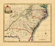
Map - Page 1 |
A New Map of Georgia with its ... |
|
S. Augustus Mitchell... |
1846 |
OML |
|
 |
Map - Page 1 - A MAP of the/BR... |
A MAP of the/BRITISH/AMERICAN ... |
|
BOWEN, EMANUEL |
1754 |
OML |
|
 |
Map - Page 1 - A MAP OF THE/UN... |
A MAP OF THE/UNITED STATES/of/... |
|
ARROWSMITH, AARON |
1799 |
OML |
|
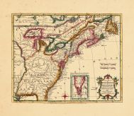 |
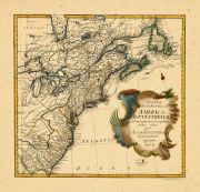
Map - Page 1 - A New MAP of/th... |
A New MAP of/the/BRITISH DOMIN... |
|
ANNUAL REGISTER / KI... |
1763 |
OML |
|
 |
Map - Page 1 - MAPPA/GEOGRAPHI... |
MAPPA/GEOGRAPHICA/AMERICAE/SEP... |
|
EULER, LEONHARD von |
1755 |
OML |
|
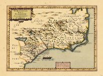 |
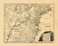
Map - Page 1 - VIRGINIA ITEM e... |
VIRGINIA ITEM et FLORIDAE |
|
DU SAUZET, HENRI |
1734 |
OML |
|
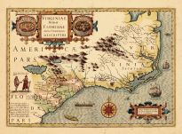 |
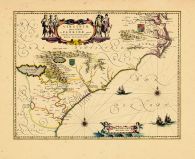
Map - Page 1 - VIRGINIAE ITEM ... |
VIRGINIAE ITEM ET FLORIDAE AME... |
|
HONDIUS, JODOCUS |
1619 |
OML |
|
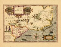 |
Map - Page 1 - VIRGINIAE ITEM ... |
VIRGINIAE ITEM ET FLORIDAE AME... |
|
HONDIUS, JODOCUS |
1630 |
OML |
|
 |
Map - Page 1 - VIRGINIAE/parti... |
VIRGINIAE/partis australis,/et... |
|
BLAEU, WILLEM |
1640 |
OML |
|
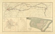 |
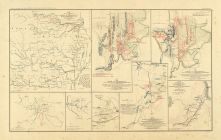
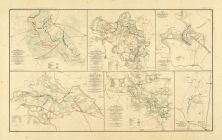
Map - Page 2 - ATLAS/TO ACCOMP... |
ATLAS/TO ACCOMPANY THE OFFICIA... |
|
DAVIS, MAJOR GEORGE ... |
1891 |
OML |
|
 |
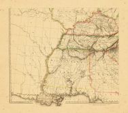
Map - Page 2 - ATLAS/TO ACCOMP... |
ATLAS/TO ACCOMPANY THE OFFICIA... |
|
DAVIS, MAJOR GEORGE ... |
1891 |
OML |
|
 |
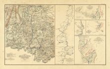
Map - Page 2 - ATLAS/TO ACCOMP... |
ATLAS/TO ACCOMPANY THE OFFICIA... |
|
DAVIS, MAJOR GEORGE ... |
1891 |
OML |
|
 |
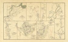
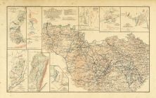
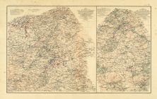
Map - Page 3 - ATLAS/TO ACCOMP... |
ATLAS/TO ACCOMPANY THE OFFICIA... |
|
DAVIS, MAJOR GEORGE ... |
1891 |
OML |
|
 |
Map - Page 3 - ATLAS/TO ACCOMP... |
ATLAS/TO ACCOMPANY THE OFFICIA... |
|
DAVIS, MAJOR GEORGE ... |
1891 |
OML |
|
 |
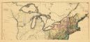
Map - Page 3 - UNITED STATES o... |
UNITED STATES of Nth. AMERICA/... |
|
TARDIEU, P.F. [AFTER... |
1812 |
OML |
|
 |
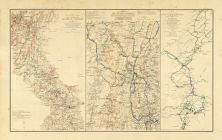
Map - Page 4 - ATLAS/TO ACCOMP... |
ATLAS/TO ACCOMPANY THE OFFICIA... |
|
DAVIS, MAJOR GEORGE ... |
1891 |
OML |
|
 |
Map - Page 4 - ATLAS/TO ACCOMP... |
ATLAS/TO ACCOMPANY THE OFFICIA... |
|
DAVIS, MAJOR GEORGE ... |
1891 |
OML |
|
 |
Map - Page 5 - ATLAS/TO ACCOMP... |
ATLAS/TO ACCOMPANY THE OFFICIA... |
|
DAVIS, MAJOR GEORGE ... |
1891 |
OML |
|
 |
Map - Page 6 - ATLAS/TO ACCOMP... |
ATLAS/TO ACCOMPANY THE OFFICIA... |
|
DAVIS, MAJOR GEORGE ... |
1891 |
OML |
|
 |
Map - Page 6 - ATLAS/TO ACCOMP... |
ATLAS/TO ACCOMPANY THE OFFICIA... |
|
DAVIS, MAJOR GEORGE ... |
1891 |
OML |
|
 |
Map 0022-00 |
LIBRO DI BENEDETTO BORDONE Nel... |
|
BORDONE, BENEDETTO |
1528 |
OML |
|
|
Map 0022-00 |
LIBRO DI BENEDETTO BORDONE Nel... |
|
BORDONE, BENEDETTO |
1528 |
OML |
|
 |
Map 0213-00 |
CLAVDII PTOLEMAEI ALEXANDRINI ... |
|
PTOLEMY, C. / SERVET... |
1541 |
OML |
|
 |
Map 0227-00 |
GEOGRAPHIA DI FRANCESCO BERLIN... |
|
PTOLEMY, C. / BERLIN... |
1482 |
OML |
|
 |
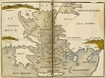
Mare [unknown] Caspium [Kingdo... |
C. IVLII SOLINI POLYHISTOR, RE... |
|
SOLINUS, C. IVLIVS/M... |
1543 |
OML |
|
 |
RVSSIAE, MOSCOVIAE ET TARTARIA... |
THEATRUM ORBIS TERRARUM |
|
ORTELIUS, ABRAHAM |
1570 |
OML |
|
 |
RVSSIAE, MOSCOVIAE ET TARTARIA... |
THEATRUM ORBIS TERRARUM |
|
ORTELIUS, ABRAHAM |
1595 |
OML |
|
 |
RVSSIAE, MOSCOVIAE ET TARTARIA... |
THEATRUM ORBIS TERRARUM |
|
ORTELIUS, ABRAHAM |
1595 |
OML |
|
 |
RVSSIAE, MOSCOVIAE ET TARTARIA... |
THEATRUM ORBIS TERRARUM |
|
ORTELIUS, ABRAHAM |
1595 |
OML |
|
 |
TABULA ASIAE III 0277-00 |
GEOGRAPHIA VNIVERSALIS,VETUS E... |
|
PTOLEMY, C. / MUNSTE... |
1545 |
OML |
|
 |
TABULA ASIAE VII 0289-00 |
GEOGRAPHIA VNIVERSALIS,VETUS E... |
|
PTOLEMY, C. / MUNSTE... |
1545 |
OML |
|
 |
TABULA GEOGRAPHICA QUA PARS RU... |
Grosser Atlas |
|
Homann, Johann Bapti... |
1716 |
OML |
|
 |
VKRANIA quae et TERRA COSACCOR... |
Grosser Atlas |
|
Homann, Johann Bapti... |
1716 |
OML |
|

 Cart
Cart